
Latest Post
Showing posts with label science. Show all posts
Showing posts with label science. Show all posts
Ancient Supervolcano Affected the Ends of the Earth
Written By Unknown on Tuesday, November 6, 2012 | 12:17 PM
About 74,000 years ago, the Toba volcano on the Indonesian island of Sumatra erupted with catastrophic force. Estimated to be 5,000 times larger than the 1980 eruption of Mount St. Helens, it is believed to be the largest volcanic event on Earth in the last 2 million years.

Sumatra, Earth's sixth-largest island, spied from space. CREDIT: NASA.
Toba spewed enough lava to build two Mount Everests, it produced huge clouds of ash that blocked sunlight for years, and it the left behind a crater 31 miles (50 kilometers) across. The volcano even sent enough sulphuric acid into the atmosphere to create acid rain downpours in the Earth's polar regions, which researchers have found evidence of in deep ice cores.
"We have now traced this acid rain in the ice caps on Greenland and Antarctica," glaciologist Anders Svensson, of the Niels Bohr Institute at the University of Copenhagen, said in a statement.
"We have long had an idea of at what depth the Toba eruption could be found in the Greenland ice cap, but we found no ash, so we could not be sure," Svensson added. "But now we have found the same series of acid layers from Toba in the Greenland ice sheet and in the ice cap in Antarctica. We have counted the annual layers between acid peaks in ice cores from the two ice caps and it fits together."
The ice cores could offer more evidence about how the changed Earth's climate was drastically changed in the years after the colossal eruption. Researchers had previously estimated that such an event would have prompted a cooling of up to 10 degrees C (18 degrees F) in the global temperature for decades, but the ice cores show the cooling was probably short and not consistent across the globe.
"In the temperature curves from the ice cores we can see that there is no general global cooling as a result of the eruption," Svensson said. "There is certainly a cooling and large fluctuations in temperature in the Northern Hemisphere, but it becomes warmer in the Southern Hemisphere, so the global cooling has been short."
The new evidence also promises to settle some archaeological debates. The Toba eruption occurred at a critical point in early human history when Homo sapiens were first venturing out of Africa into Asia. However, there is wide disagreement about how early human were affected and whether large parts of the population were wiped out by the blast.
Layers of ash from the Toba eruption have been found in Asia and serve as a very important reference horizon for ancient archaeological clues from this period that are too old to be carbon dated. The ice cores now provide another backdrop against which to place ancient finds.
"The new precise location of the Toba eruption in the ice cores will place the archaeological finds in a climatic context, which will help to shed light on this critical period of human history," Svensson said.
The study is detailed in the journal Climate of the Past.
by LiveScience Staff, www.livescience.com
Easter Island
Written By Unknown on Thursday, November 1, 2012 | 1:44 PM
If They Could Only Talk

Easter Island covers just 63 square miles. It lies 2,150 miles west of South America and 1,300 miles east of Pitcairn, its nearest inhabited neighbor. After it was settled, it remained isolated for centuries. All the energy and resources that went into the moai—which range in height from four to 33 feet and in weight to more than 80 tons—came from the island itself. Yet when Dutch explorers landed on Easter Sunday in 1722, they met a Stone Age culture. The moai were carved with stone tools, mostly in a single quarry, then transported without draft animals or wheels to massive stone platforms, or ahu, up to 11 miles away. Tuki’s question—how did they do it?—has vexed legions of visitors in the past half century.
But lately the moai have been drawn into a larger debate, one that opposes two distinct visions of Easter Island’s past—and of humanity in general. The first, eloquently expounded by Pulitzer Prize winner Jared Diamond, presents the island as a cautionary parable: the most extreme case of a society wantonly destroying itself by wrecking its environment. Can the whole planet, Diamond asks, avoid the same fate? In the other view, the ancient Rapanui are uplifting emblems of human resilience and ingenuity—one example being their ability to walk giant statues upright across miles of uneven terrain.
When the Polynesian settlers arrived at Rapa Nui, they had been at sea for weeks in open canoes. There were probably only a few dozen of them. Nowadays 12 flights arrive every week from Chile, Peru, and Tahiti, and in 2011 those planes delivered 50,000 tourists, ten times the island’s population. Just three decades ago, cars, electricity, and phone service were scarce; now Hanga Roa, the only town, buzzes with Internet cafés, bars, and dance clubs, and cars and pickup trucks clog the streets on Saturday nights. Wealthy tourists drop a thousand dollars a night at the poshest of scores of hotels. A Birkenstock shop caters to footsore ramblers. “The island is not an island anymore,” says Kara Pate, 40, a Rapanui sculptor. She’s married to a German she met here 23 years ago.
Chile annexed Easter Island in 1888, but until 1953 it allowed a Scottish company to manage the island as a giant sheep ranch. The sheep ranged freely, while the Rapanui were penned into Hanga Roa. In 1964 they revolted, later obtaining Chilean citizenship and the right to elect their own mayor.
Ambivalence toward el conti (the continent) runs high. Easter Islanders depend on Chile for fuel and daily air shipments of food. They speak Spanish and go to the mainland for higher education. Meanwhile, Chilean migrants, lured in part by the island’s income tax exemption, gladly take jobs that Rapanui spurn. “A Rapanui will say, What, you think I’m going to wash dishes?” says Beno Atán, a 27-year-old tour guide and a native himself. Though many Rapanui have married mainlanders, some worry their culture is being diluted. The population is now around 5,000, nearly double what it was 20 years ago, and fewer than half the people are Rapanui.
Just about every job on Easter Island depends on tourism. “Without it,” says Mahina Lucero Teao, head of the tourism chamber, “everyone would be starving on the island.” The mayor, Luz Zasso Paoa, says, “Our patrimony is the base of our economy. You’re not here for us, but for that patrimony.” That is, for the moai.
Thor Heyerdahl, the Norwegian ethnographer and adventurer whose Pacific expeditions helped ignite the world’s curiosity about Easter Island, thought the statues had been created by pre-Inca from Peru, not by Polynesians. Erich von Däniken, the best-selling Swiss author of Chariots of the Gods, was sure the moai were built by stranded extraterrestrials. Modern science—linguistic, archaeological, and genetic evidence—has proved the moai builders were Polynesian but not how they moved their creations. Researchers have tended to assume the ancestors dragged the statues somehow, using a lot of ropes and wood. “The experts can say whatever they want,” says Suri Tuki, 25, José Tuki’s half brother. “But we know the truth. The statues walked.” In the Rapanui oral tradition, the moai were animated by mana, a spiritual force transmitted by powerful ancestors.
There are no reports of moai building after Europeans arrived in the 18th century. By then Easter Island had only a few scrawny trees. In the 1970s and 1980s, though, biogeographer John Flenley of New Zealand’s Massey University found evidence—pollen preserved in lake sediments—that the island had been covered in lush forests, including millions of giant palm trees, for thousands of years. Only after the Polynesians arrived around A.D. 800 had those forests given way to grasslands.
Jared Diamond drew heavily on Flenley’s work for his assertion in Collapse, his influential 2005 book, that ancient Easter Islanders committed unintentional ecocide. They had the bad luck, Diamond argues, to have settled an extremely fragile island—dry, cool, and remote, which means it’s poorly fertilized by windblown dust or volcanic ash. (Its own volcanoes are quiescent.) When the islanders cleared the forests for firewood and farming, the forests didn’t grow back. As wood became scarce and the islanders could no longer build seagoing canoes for fishing, they ate the birds. Soil erosion decreased their crop yields. Before Europeans showed up, the Rapanui had descended into civil war and cannibalism. The collapse of their isolated civilization, Diamond writes, is “the clearest example of a society that destroyed itself by overexploiting its own resources” and “a worst-case scenario for what may lie ahead of us in our own future.”
The moai, he thinks, accelerated the self-destruction. Diamond interprets them as power displays by rival chieftains who, trapped on a remote little island, lacked other ways of strutting their stuff. They competed by building ever bigger statues. Diamond thinks they laid the moai on wooden sledges, hauled over log rails—a technique successfully tested by UCLA archaeologist Jo Anne Van Tilburg, director of the Easter Island Statue Project—but that required both a lot of wood and a lot of people. To feed the people, even more land had to be cleared. When the wood was gone and civil war began, the islanders began toppling the moai. By the 19th century none were standing. Easter Island’s landscape acquired the aura of tragedy that, in the eyes of Diamond and many others, it retains today.
Rearrange and reinterpret the scattered shards of fact, though, and you get a more optimistic vision of the Rapa Nui past—that of archaeologists Terry Hunt of the University of Hawaii and Carl Lipo of California State University Long Beach, who have studied the island for the past decade. It’s a vision peopled by peaceful, ingenious moai builders and careful stewards of the land. Hunt and Lipo agree that Easter Island lost its lush forests and that it was an “ecological catastrophe”—but the islanders themselves weren’t to blame. And the moai certainly weren’t. There is indeed much to learn from Easter Island, Hunt says, “but the story is different.”
His and Lipo’s controversial new version, based on their research and others’, begins with their own excavation at Anakena beach. It has convinced them that the Polynesians didn’t arrive until A.D. 1200, about four centuries later than is commonly understood, which would leave them only five centuries to denude the landscape. Slashing and burning wouldn’t have been enough, Hunt and Lipo think. Anyway, another tree killer was present. When archaeologists dig up nuts from the extinct Easter Island palm, the nuts are often marred by tiny grooves, made by the sharp teeth of Polynesian rats.
The rats arrived in the same canoes as the first settlers. Abundant bones in the Anakena dig suggest the islanders dined on them, but otherwise the rodents had no predators. In just a few years, Hunt and Lipo calculate, they would have overrun the island. Feasting on palm nuts, they would have prevented the reseeding of the slow-growing trees and thereby doomed Rapa Nui’s forest, even if humans hadn’t been slashing and burning. No doubt the rats ate birds’ eggs too.
Of course, the settlers bear responsibility for bringing the rats; Hunt and Lipo suspect they did so intentionally. (They also brought chickens.) But like invasive species today, the Polynesian rats did more harm to the ecosystem than to the humans who transported them. Hunt and Lipo see no evidence that Rapanui civilization collapsed when the palm forest did; based on their own archaeological survey of the island, they think its population grew rapidly after settlement to around 3,000 and then remained more or less stable until the arrival of Europeans.
Cleared fields were more valuable to the Rapanui than palm forests were. But they were wind-lashed, infertile fields watered by erratic rains. Easter Island was a tough place to make a living. It required heroic efforts. In farming, as in moai moving, the islanders shifted monumental amounts of rock—but into their fields, not out. They built thousands of circular stone windbreaks, called manavai, and gardened inside them. They mulched whole fields with broken volcanic rocks to keep the soil moist and fertilized it with nutrients that the volcanoes were no longer spreading. In short, Hunt, Lipo, and others contend, the prehistoric Rapanui were pioneers of sustainable farming, not inadvertent perpetrators of ecocide. “Rather than a case of abject failure, Rapa Nui is an unlikely story of success,” Hunt and Lipo argue in their recent book.
It’s called The Statues That Walked, and the Rapanui enjoy better spin in it than they do in Collapse. Hunt and Lipo don’t trust oral history accounts of violent conflict among the Rapanui; sharp obsidian flakes that other archaeologists see as weapons, they see as farm tools. The moai helped keep the peace, they argue, not only by signaling the power of their builders but also by limiting population growth: People raised statues rather than children. What’s more, moving the moai required few people and no wood, because they were walked upright. On that issue, Hunt and Lipo say, evidence supports the folklore.
Sergio Rapu, 63, a Rapanui archaeologist and former Easter Island governor who did graduate work with Hunt, took his American colleagues to the ancient quarry on Rano Raraku, the island’s southeastern volcano. Looking at the many moai abandoned there in various stages of completion, Rapu explained how they were engineered to walk: Fat bellies tilted them forward, and a D-shaped base allowed handlers to roll and rock them side to side. Last year, in experiments funded by National Geographic’s Expeditions Council, Hunt and Lipo showed that as few as 18 people could, with three strong ropes and a bit of practice, easily maneuver a 10-foot, 5-ton moai replica a few hundred yards. In real life, walking miles with much larger moai would have been a tense business. Dozens of fallen statues line the roads leading away from the quarry. But many more made it to their platforms intact.
No one knows for sure when the last statue was carved. The moai cannot be dated directly. Many were still standing when the Dutch arrived in 1722, and Rapanui civilization was peaceful and thriving then, Hunt and Lipo argue. But the explorers introduced deadly diseases to which islanders had no immunity, along with artifacts that replaced the moai as status symbols. Snatching Europeans’ hats—Hunt and Lipo cite many reports of this—became more appealing than hoisting a multiton red pukao onto a moai. In the 19th century slave traders decimated the population, which shriveled to 111 people by 1877.
As Hunt and Lipo tell it, Easter Island’s story is a parable of genocide and culturecide, not ecocide. Their friend Sergio Rapu buys some but not all of it. “Don’t tell me those obsidian tools were just for agriculture,” he says, laughing. “I’d love to hear that my people never ate each other. But I’m afraid they did.”
Today islanders confront a fresh challenge: exploiting their cultural legacy without wrecking it. A growing population and thousands of tourists are straining a limited water supply. The island lacks a sewer system and a place to put the swelling volume of trash; between 2009 and mid-2011 it shipped 230 tons to the mainland. “So what do we do?” asks Zasso Paoa, the mayor. “Limit migration? Limit tourism? That’s where we are now.” The island recently started asking tourists to take their trash home with them in their suitcases.
Tourists are forbidden to touch moai, but horses happily rub against them, wearing away the porous tuff. Though cars are now the preferred mode of transport, more than 6,000 horses and cattle—“more than people,” grumbles tour guide Atán—still run free, trampling ground once trodden by Scottish-owned sheep and relieving themselves on once sacred platforms. But the islanders’ own desire to develop their ancestral lands may be a greater threat to their densely packed heritage: more than 20,000 archaeological features in all, including walled gardens and stone chicken houses as well as moai and ahu. More than 40 percent of the island is a protected national park, which limits available land. “People have to learn that archaeology isn’t their enemy,” says Rapu.
Decades ago he himself helped get the moai at Anakena back upright. In the process he and his colleagues also discovered how the moai builders had breathed soul into their colossal statues after the long trek from the quarry: As a finishing touch, they placed eyes of white coral and pupils of obsidian or red scoria into the empty sockets.
A grove of coconut palms, imported from Tahiti, overlooks Anakena beach today, reassuring sunbathers and Chilean newlyweds that they really are in Polynesia, even if the wind is shrieking and the grassy rolling hills behind them look like the Scottish Highlands. The moai are eyeless now and not confiding—to the tourists, José Tuki, or anyone else—how they got there or which story of Easter Island is true. Tuki, for one, can handle the ambiguity. “I want to know the truth,” he says. “But maybe the island doesn’t tell all its answers. And maybe knowing everything would take its power away.”
ngm.nationalgeographic.com
Location


Lying isolated in the East Pacific, in an extreme windward position, Rapa Nui is the easternmost Polynesian island. It is in the Southern Hemisphere at 27° 9’ S latitude, 109° 26’ W longitude. Situated on the Nazca Plate at a volcanic and tectonic “hot spot,” it is 3703 km west of South America and 1819 km east of Pitcairn island. The total land area is 163.6 sq km or 63.2 sq mi.
Environment

The island lacks a reef, but there are six known species of coral present, two of which are endemic. Coral was used to fashion eyeballs for the monolithic statues. The island is roughly 160 sq. km in area. The climate is subtropical to temperate, with an average annual temperature of 22 C and average rainfall between 1250 and 1500 mm per year. Winds are nearly constant, with southeast trade winds dominant from October to April. Environmental hazards include tsunami (tidal waves) and drought.

Topography
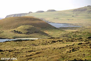
The Rapa Nui landscape is one of gently rolling hills and slopes irregularly punctuated by volcanic cones. Lava plains are frequently densely carpeted with loose rock cover. Maximum elevation is 510 m above sea level. Fresh water is found in two large crater lakes, and seasonal streams flow from Maunga Terevaka vicinity.
Geology

Rapa Nui is a Pacific high island, formed by the coalescing flows of three Pliocene to Holocene age volcanoes. Basalts and andesitic rocks are characteristic, and soils are predominately loams and clays. In part because of previous deforestation, soil erosion is a problem today. The island’s most culturally significant geological resource is Rano Raraku, a volcanic crater of concentrated ash, or tuff, from which the monolithic statues, or moai, were carved.

Flora

Rapa Nui was largely forested before humans settled it. About 16 species of trees or woody shrubs existed, and at least one large palm (similar to Jubea chilensis). An alternative hypothesis is that the island was grass-covered with palm trees and shrubs concentrated in lowland areas. In either case, the island was largely deforested by the coming of Europeans in 1722. Scripus californicus, commonly called the totora reed, colonized the island by natural means some 30,000 years ago. It is widely agreed that deforestation attained a level of irreversibility, and had significant ecological repercussions. There is, however, considerable scholarly debate about the proportionate interaction of human and natural forces—such as drought, for example—in bringing about deforestation.

Fauna
There were no indigenous large or small mammals on Rapa Nui before human settlement. There were, however, insects and at least one species of lizard. Twenty-five seabird species, from sub-Arctic to tropical, and six types of land birds are archaeologically known. Of 111-140 species of fish inhabiting the marginal marine ecosystem, only 54 of them are near-shore or offshore species. Human impact on birds was significant, and caused the extinction of about half a dozen land birds and several dozen seabirds. Central South Pacific planktons were a major food source for migrating tuna and other large fish important to the Rapa Nui economy.
About Prehistoric Rapa Nui Society
Social Organization
The basic social units on Rapa Nui were the family (paenga), the lineage (ivi) and the clan (mata). A cluster of defined features, including the hearth (umu pae), marks households archaeologically. Households were linked to the extended clan through a complex web of economic and social obligations that prompted and sustained cooperative exchange of goods, wives, and labor. This method of organization is called the conical clan. The paramount chief (ariki mau) was at the peak of the social pyramid. Public work projects, including the construction of image ahu (temples) and the erection of monolithic statues (moai), were the driving economic forces in food production, storage, display, and redistribution.
 An elliptical, high status house foundation (hare paenga) near Tahai, 1983. Photo by: Jo Anne Van Tilburg. © Jo Anne Van Tlburg/EISP.
Political Organization
The Rapa Nui chiefdom was organized in the same basic manner as all other Polynesian chiefdoms. The paramount chief (ariki mau) was drawn from the Honga lineage of the ruling Miru clan, and was descended directly from Hotu Matu’a, the legendary founding ancestor of the entire Rapa Nui family. Associated with the site of Anakena, he was considered to be the repository of divine power called mana. Subordinate chiefs (ariki paka) in the same direct line were arrayed below, and non-direct line chiefs (honui) followed. Each had power (mana) and sanctity (tapu) corresponding to their hereditary rank and status. All non-chiefs and other members of society also held ranked positions, but status could be acquired through demonstrated excellence or leadership.
Division of Labor

Culturally dictated gender specialization made many work tasks (such as fishing) forbidden, or tapu to women. Tools were often sanctified. Human bone, for example, was sometimes used for fishhooks, and may have been believed to incorporate the mana of deceased expert (maori) fisherman. Expert carvers of statues used stone tools (toki). All professions were organized, and those who belonged to esteemed societies or guilds were treated as privileged. Skills were passed down from one generation to the next in an organized manner.
Access to Resources
Resource management, including access to prestige goods and restricted resources, was guided by the hierarchical power structure. Some resources were controlled through the traditional Polynesian system of tapu restrictions. The paramount chief and expert fishermen, for example, controlled access to deep-water fish resources. Stone of at least three types was restricted to specific uses. Rano Raraku, the volcanic quarry from which 95% of the statues was hewn, is surrounded at its base by a ring of elliptical house foundations (hare paenga) widely interpreted as the remains of high-status dwellings. This suggests control of the stone by a ritual or technological elite.
Conflict

Archaeologists, linguists and osteologists have established that competition and conflict are fundamental structural characteristics of ancient Polynesian chiefdoms. On Rapa Nui, social tensions were deep and conflict emerged at different times at various levels of society. It became more pervasive when the upward trajectory of population growth and public works—including the making of monolithic statues—intersected with the downward spiral caused by deforestation and resource depletion. Obsidian spear points (mata’a) appear in large numbers in late archaeological contexts. Two large regional polities existed: the lower ranking, eastern group of clans was known as Hotu Iti; the higher-ranking, western group was Ko Tu’u. Warriors (toa) were members of a professional guild or class and wore distinguishing feather headdresses. Expert warriors (matatoa), in the opinions of some researchers, eventually usurped all but the most basic rights of the traditional paramount chief.
Rapa Nui Religion, Art, and Aesthetics
The Rapa Nui Universe
Rapa Nui people saw the world as dualistic, and structured the universe symbolically into horizontal and vertical space. Gods were responsible for maintaining permanence. The sky world (light) and the underworld (dark) were separated—but also joined—by the terrestrial realm (kainga). Rapa Nui gods, in the Polynesian tradition, were chiefly ancestors who derived their power (mana) directly from major gods (atua). The clan gods of the Miru, the paramount clan, were the traditional Polynesian male god Tiki and Makemake, said to be the supreme creator god. Lesser spirits and dangerous ghosts (akuaku) roamed individual family lands.
Ancestral Gods

 Moai 88 and 89, from exterior slope of Rano Raraku, Rapa Nui (Easter Island). Photo by: David C. Ochnser. copyright Jo Anne Van Tilburg/EISP.
Ancestral gods were the sources of personal protection for the soul and body during life and in afterlife. They guarded lineage territory and personal property from humans and demons, and were responsible for increasing food. They were believed to bring migrating birds and fish to the island, to improve soil fertility and produce new plants, and to increase the human population. The monolithic statues (moai) are universally regarded on Rapa Nui today as representations of chiefly, deified ancestors. They are the “living faces” (aringa ora) of the past.

Religious Practitioners
The highest-ranking Rapa Nui priests were the powerful ivi atua. They conducted the most complex mortuary ceremonies before the massive, upright moai on image ahu. Ivi atua are linked with stone towers called tupa, where they interpreted signs from the natural world and intoned prophesies related to planting, harvesting, and fishing. A special group of priests created and controlled kohau rongorongo, wood boards or staves with rows of tiny, carved symbols. They employed these symbols in chanting or singing during rituals held at Orongo, a ceremonial village on the rim of a volcano called Rano Kau. There were other, lower ranking male and female spiritual practitioners, including sorcerers, healers, diviners, and prophets.
Burial

Rapa Nui mortuary practices included the exposure of the corpse on a raised bier in front of the image ahu. Cremation was conducted at the rear of the ahu. Burial practices changed after about A.D. 1400-1500, and tombs were excavated into ahu that had been converted into semi-pyramidal structures by covering fallen moai with a mantle of rubble. Burials were also placed within the ahu fill, in boat-shaped or wedge-shaped stone structures called ahu poepoe, and in rectangular avanga. Some cave burials are known. A scatter of red scoria stone or broken white coral is usually associated with burials or cremations. Preservation of the human skull was common, especially when the deceased was high-ranking.
Arts
The rich Rapa Nui aesthetic tradition is rooted in Polynesian forms and emphases. Yet it has its own unique, consistent iconographic vocabulary. The human form is most commonly depicted in sculpture, followed by bird and marine forms. Many objects, including some moai, show evidence of having been painted red or white. A diagnostic characteristic of Rapa Nui sculpture, including rock art, is a “morphosis” or transformational quality (a being turning into another being). In addition to sculpture, tattoo and some rock art were well advanced. A very few superb objects made of feathers, barkcloth (tapa), or shell have been preserved in museum collections. Contemporary arts on Rapa Nui are vibrantly alive.
 Erosion on the north coast of Rapa Nui (Easter Island), 1989. Photo: David C. Ochsner, copyright Jo Anne Van Tilburg/EISP.
Want to know more?
Baker, P.E. 1967. “Preliminary account of recent geological investigations on Easter Island.” Geology Magazine 104:2.
Hunter-Anderson, R. 1989. “Human vs. climatic impacts at Rapa Nui: Did the people really cut down all those trees?” In Easter Island in Pacific Context: South Seas Symposium, ed. C.M. Stevenson et al. Los Osos, CA: Easter Island Foundation Occasional Paper 4, 85-99.
Martinsson-Wallen, H. 1994. Ahu—The ceremonial stone structures of Easter Island. Uppsala: Societas Archaeological Upsaliensis Aun 19. Orliac, C. 2000. “Des arbres à l’île de Pâques entre le 14 ème siècle de notre ère.” Paris: L’Archèologie “Errance.”
Steadman, D.W., P. Vargas and C. Cristino 1994. “Stratigraphy, chronology, and cultural context of an early faunal assemblage from Easter Island.” Asian Perspectives 33: 79-96.
Van Tilburg, J. 2001. “Easter Island.” In P.N. Pergrine and M. Ember (eds.), Encyclopedia of Prehistory. Human Relations Area Files at Yale University. New York: Kluwer Academic/Plenum.
ABOUT THE AUTHOR
Jo Anne Van Tilburg, Ph.D. — Archaeologist; Director, UCLA Rock Art Archive, Cotsen Institute of Archaeology; Project Director, Easter Island Statue Project Conservation Initiative
www.eisp.org

“The statues walked,” Easter Islanders say. Archaeologists are still trying to figure out how—and whether their story is a cautionary tale of environmental disaster or a celebration of human ingenuity.
By Hannah Bloch
Video Animation by Hans Weise, Spencer Millsap, Fernando G. Baptista, and Fanna Gebreyesus
On a winter night last June, José Antonio Tuki, a 30-year-old artist on Easter Island, did one of the things he loves best: He left his one-room home on the southwest coast and hiked north across the island to Anakena beach. Legend has it the earliest Polynesian settlers hauled their canoes ashore at Anakena a thousand years ago or so, after navigating more than a thousand miles of open Pacific. Under the same moon and stars Tuki sat on the sand and gazed directly before him at the colossal human statues—the moai. Carved centuries ago from volcanic tuff, they’re believed to embody the deified spirits of ancestors.
Sleepless roosters crowed; stray dogs barked. A frigid wind gusted in from Antarctica, making Tuki shiver. He’s a Rapanui, an indigenous Polynesian resident of Rapa Nui, as the locals call Easter Island; his own ancestors probably helped carve some of the hundreds of statues that stud the island’s grassy hills and jagged coasts. At Anakena seven potbellied moai stand at attention on a 52-foot-long stone platform—backs to the Pacific, arms at their sides, heads capped with tall pukao of red scoria, another volcanic rock. They watch over this remote island from a remote age, but when Tuki stares at their faces, he feels a surge of connection. “It’s something strange and energetic,” he says. “This is something produced from my culture. It’s Rapanui.” He shakes his head. “How did they do it?”
Easter Island covers just 63 square miles. It lies 2,150 miles west of South America and 1,300 miles east of Pitcairn, its nearest inhabited neighbor. After it was settled, it remained isolated for centuries. All the energy and resources that went into the moai—which range in height from four to 33 feet and in weight to more than 80 tons—came from the island itself. Yet when Dutch explorers landed on Easter Sunday in 1722, they met a Stone Age culture. The moai were carved with stone tools, mostly in a single quarry, then transported without draft animals or wheels to massive stone platforms, or ahu, up to 11 miles away. Tuki’s question—how did they do it?—has vexed legions of visitors in the past half century.
But lately the moai have been drawn into a larger debate, one that opposes two distinct visions of Easter Island’s past—and of humanity in general. The first, eloquently expounded by Pulitzer Prize winner Jared Diamond, presents the island as a cautionary parable: the most extreme case of a society wantonly destroying itself by wrecking its environment. Can the whole planet, Diamond asks, avoid the same fate? In the other view, the ancient Rapanui are uplifting emblems of human resilience and ingenuity—one example being their ability to walk giant statues upright across miles of uneven terrain.
When the Polynesian settlers arrived at Rapa Nui, they had been at sea for weeks in open canoes. There were probably only a few dozen of them. Nowadays 12 flights arrive every week from Chile, Peru, and Tahiti, and in 2011 those planes delivered 50,000 tourists, ten times the island’s population. Just three decades ago, cars, electricity, and phone service were scarce; now Hanga Roa, the only town, buzzes with Internet cafés, bars, and dance clubs, and cars and pickup trucks clog the streets on Saturday nights. Wealthy tourists drop a thousand dollars a night at the poshest of scores of hotels. A Birkenstock shop caters to footsore ramblers. “The island is not an island anymore,” says Kara Pate, 40, a Rapanui sculptor. She’s married to a German she met here 23 years ago.
Chile annexed Easter Island in 1888, but until 1953 it allowed a Scottish company to manage the island as a giant sheep ranch. The sheep ranged freely, while the Rapanui were penned into Hanga Roa. In 1964 they revolted, later obtaining Chilean citizenship and the right to elect their own mayor.
Ambivalence toward el conti (the continent) runs high. Easter Islanders depend on Chile for fuel and daily air shipments of food. They speak Spanish and go to the mainland for higher education. Meanwhile, Chilean migrants, lured in part by the island’s income tax exemption, gladly take jobs that Rapanui spurn. “A Rapanui will say, What, you think I’m going to wash dishes?” says Beno Atán, a 27-year-old tour guide and a native himself. Though many Rapanui have married mainlanders, some worry their culture is being diluted. The population is now around 5,000, nearly double what it was 20 years ago, and fewer than half the people are Rapanui.
Just about every job on Easter Island depends on tourism. “Without it,” says Mahina Lucero Teao, head of the tourism chamber, “everyone would be starving on the island.” The mayor, Luz Zasso Paoa, says, “Our patrimony is the base of our economy. You’re not here for us, but for that patrimony.” That is, for the moai.
Thor Heyerdahl, the Norwegian ethnographer and adventurer whose Pacific expeditions helped ignite the world’s curiosity about Easter Island, thought the statues had been created by pre-Inca from Peru, not by Polynesians. Erich von Däniken, the best-selling Swiss author of Chariots of the Gods, was sure the moai were built by stranded extraterrestrials. Modern science—linguistic, archaeological, and genetic evidence—has proved the moai builders were Polynesian but not how they moved their creations. Researchers have tended to assume the ancestors dragged the statues somehow, using a lot of ropes and wood. “The experts can say whatever they want,” says Suri Tuki, 25, José Tuki’s half brother. “But we know the truth. The statues walked.” In the Rapanui oral tradition, the moai were animated by mana, a spiritual force transmitted by powerful ancestors.
There are no reports of moai building after Europeans arrived in the 18th century. By then Easter Island had only a few scrawny trees. In the 1970s and 1980s, though, biogeographer John Flenley of New Zealand’s Massey University found evidence—pollen preserved in lake sediments—that the island had been covered in lush forests, including millions of giant palm trees, for thousands of years. Only after the Polynesians arrived around A.D. 800 had those forests given way to grasslands.
Jared Diamond drew heavily on Flenley’s work for his assertion in Collapse, his influential 2005 book, that ancient Easter Islanders committed unintentional ecocide. They had the bad luck, Diamond argues, to have settled an extremely fragile island—dry, cool, and remote, which means it’s poorly fertilized by windblown dust or volcanic ash. (Its own volcanoes are quiescent.) When the islanders cleared the forests for firewood and farming, the forests didn’t grow back. As wood became scarce and the islanders could no longer build seagoing canoes for fishing, they ate the birds. Soil erosion decreased their crop yields. Before Europeans showed up, the Rapanui had descended into civil war and cannibalism. The collapse of their isolated civilization, Diamond writes, is “the clearest example of a society that destroyed itself by overexploiting its own resources” and “a worst-case scenario for what may lie ahead of us in our own future.”
The moai, he thinks, accelerated the self-destruction. Diamond interprets them as power displays by rival chieftains who, trapped on a remote little island, lacked other ways of strutting their stuff. They competed by building ever bigger statues. Diamond thinks they laid the moai on wooden sledges, hauled over log rails—a technique successfully tested by UCLA archaeologist Jo Anne Van Tilburg, director of the Easter Island Statue Project—but that required both a lot of wood and a lot of people. To feed the people, even more land had to be cleared. When the wood was gone and civil war began, the islanders began toppling the moai. By the 19th century none were standing. Easter Island’s landscape acquired the aura of tragedy that, in the eyes of Diamond and many others, it retains today.
Rearrange and reinterpret the scattered shards of fact, though, and you get a more optimistic vision of the Rapa Nui past—that of archaeologists Terry Hunt of the University of Hawaii and Carl Lipo of California State University Long Beach, who have studied the island for the past decade. It’s a vision peopled by peaceful, ingenious moai builders and careful stewards of the land. Hunt and Lipo agree that Easter Island lost its lush forests and that it was an “ecological catastrophe”—but the islanders themselves weren’t to blame. And the moai certainly weren’t. There is indeed much to learn from Easter Island, Hunt says, “but the story is different.”
His and Lipo’s controversial new version, based on their research and others’, begins with their own excavation at Anakena beach. It has convinced them that the Polynesians didn’t arrive until A.D. 1200, about four centuries later than is commonly understood, which would leave them only five centuries to denude the landscape. Slashing and burning wouldn’t have been enough, Hunt and Lipo think. Anyway, another tree killer was present. When archaeologists dig up nuts from the extinct Easter Island palm, the nuts are often marred by tiny grooves, made by the sharp teeth of Polynesian rats.
The rats arrived in the same canoes as the first settlers. Abundant bones in the Anakena dig suggest the islanders dined on them, but otherwise the rodents had no predators. In just a few years, Hunt and Lipo calculate, they would have overrun the island. Feasting on palm nuts, they would have prevented the reseeding of the slow-growing trees and thereby doomed Rapa Nui’s forest, even if humans hadn’t been slashing and burning. No doubt the rats ate birds’ eggs too.
Of course, the settlers bear responsibility for bringing the rats; Hunt and Lipo suspect they did so intentionally. (They also brought chickens.) But like invasive species today, the Polynesian rats did more harm to the ecosystem than to the humans who transported them. Hunt and Lipo see no evidence that Rapanui civilization collapsed when the palm forest did; based on their own archaeological survey of the island, they think its population grew rapidly after settlement to around 3,000 and then remained more or less stable until the arrival of Europeans.
Cleared fields were more valuable to the Rapanui than palm forests were. But they were wind-lashed, infertile fields watered by erratic rains. Easter Island was a tough place to make a living. It required heroic efforts. In farming, as in moai moving, the islanders shifted monumental amounts of rock—but into their fields, not out. They built thousands of circular stone windbreaks, called manavai, and gardened inside them. They mulched whole fields with broken volcanic rocks to keep the soil moist and fertilized it with nutrients that the volcanoes were no longer spreading. In short, Hunt, Lipo, and others contend, the prehistoric Rapanui were pioneers of sustainable farming, not inadvertent perpetrators of ecocide. “Rather than a case of abject failure, Rapa Nui is an unlikely story of success,” Hunt and Lipo argue in their recent book.
It’s called The Statues That Walked, and the Rapanui enjoy better spin in it than they do in Collapse. Hunt and Lipo don’t trust oral history accounts of violent conflict among the Rapanui; sharp obsidian flakes that other archaeologists see as weapons, they see as farm tools. The moai helped keep the peace, they argue, not only by signaling the power of their builders but also by limiting population growth: People raised statues rather than children. What’s more, moving the moai required few people and no wood, because they were walked upright. On that issue, Hunt and Lipo say, evidence supports the folklore.
Sergio Rapu, 63, a Rapanui archaeologist and former Easter Island governor who did graduate work with Hunt, took his American colleagues to the ancient quarry on Rano Raraku, the island’s southeastern volcano. Looking at the many moai abandoned there in various stages of completion, Rapu explained how they were engineered to walk: Fat bellies tilted them forward, and a D-shaped base allowed handlers to roll and rock them side to side. Last year, in experiments funded by National Geographic’s Expeditions Council, Hunt and Lipo showed that as few as 18 people could, with three strong ropes and a bit of practice, easily maneuver a 10-foot, 5-ton moai replica a few hundred yards. In real life, walking miles with much larger moai would have been a tense business. Dozens of fallen statues line the roads leading away from the quarry. But many more made it to their platforms intact.
No one knows for sure when the last statue was carved. The moai cannot be dated directly. Many were still standing when the Dutch arrived in 1722, and Rapanui civilization was peaceful and thriving then, Hunt and Lipo argue. But the explorers introduced deadly diseases to which islanders had no immunity, along with artifacts that replaced the moai as status symbols. Snatching Europeans’ hats—Hunt and Lipo cite many reports of this—became more appealing than hoisting a multiton red pukao onto a moai. In the 19th century slave traders decimated the population, which shriveled to 111 people by 1877.
As Hunt and Lipo tell it, Easter Island’s story is a parable of genocide and culturecide, not ecocide. Their friend Sergio Rapu buys some but not all of it. “Don’t tell me those obsidian tools were just for agriculture,” he says, laughing. “I’d love to hear that my people never ate each other. But I’m afraid they did.”
Today islanders confront a fresh challenge: exploiting their cultural legacy without wrecking it. A growing population and thousands of tourists are straining a limited water supply. The island lacks a sewer system and a place to put the swelling volume of trash; between 2009 and mid-2011 it shipped 230 tons to the mainland. “So what do we do?” asks Zasso Paoa, the mayor. “Limit migration? Limit tourism? That’s where we are now.” The island recently started asking tourists to take their trash home with them in their suitcases.
Tourists are forbidden to touch moai, but horses happily rub against them, wearing away the porous tuff. Though cars are now the preferred mode of transport, more than 6,000 horses and cattle—“more than people,” grumbles tour guide Atán—still run free, trampling ground once trodden by Scottish-owned sheep and relieving themselves on once sacred platforms. But the islanders’ own desire to develop their ancestral lands may be a greater threat to their densely packed heritage: more than 20,000 archaeological features in all, including walled gardens and stone chicken houses as well as moai and ahu. More than 40 percent of the island is a protected national park, which limits available land. “People have to learn that archaeology isn’t their enemy,” says Rapu.
Decades ago he himself helped get the moai at Anakena back upright. In the process he and his colleagues also discovered how the moai builders had breathed soul into their colossal statues after the long trek from the quarry: As a finishing touch, they placed eyes of white coral and pupils of obsidian or red scoria into the empty sockets.
A grove of coconut palms, imported from Tahiti, overlooks Anakena beach today, reassuring sunbathers and Chilean newlyweds that they really are in Polynesia, even if the wind is shrieking and the grassy rolling hills behind them look like the Scottish Highlands. The moai are eyeless now and not confiding—to the tourists, José Tuki, or anyone else—how they got there or which story of Easter Island is true. Tuki, for one, can handle the ambiguity. “I want to know the truth,” he says. “But maybe the island doesn’t tell all its answers. And maybe knowing everything would take its power away.”
ngm.nationalgeographic.com
Facts About Rapa Nui (Easter Island)
Jo Anne Van Tilburg, Ph.D.

Map showing the location of Rapa Nui (Easter Island) within the Pacific Ocean and the Polynesian triangle.

Map showing the Nazca Plate, on which Rapa Nui (Easter Island) is located.
Lying isolated in the East Pacific, in an extreme windward position, Rapa Nui is the easternmost Polynesian island. It is in the Southern Hemisphere at 27° 9’ S latitude, 109° 26’ W longitude. Situated on the Nazca Plate at a volcanic and tectonic “hot spot,” it is 3703 km west of South America and 1819 km east of Pitcairn island. The total land area is 163.6 sq km or 63.2 sq mi.
Environment
Climate

Pacific Breakers on the south coast of Rapa Nui (Easter Island), 1983. Photo: David C. Ochsner, copyright Jo Anne Van Tilburg/EISP.
The island lacks a reef, but there are six known species of coral present, two of which are endemic. Coral was used to fashion eyeballs for the monolithic statues. The island is roughly 160 sq. km in area. The climate is subtropical to temperate, with an average annual temperature of 22 C and average rainfall between 1250 and 1500 mm per year. Winds are nearly constant, with southeast trade winds dominant from October to April. Environmental hazards include tsunami (tidal waves) and drought.

Coral along the coast of Rapa Nui (Easter Island), 1983. Photo: David C. Ochsner, copyright Jo Anne Van Tilburg/EISP.
Topography

Rolling, treeless terrain of Rapa Nui (Easter Island), 1984. Photo: David C. Ochsner, copyright Jo Anne Van Tilburg/EISP.
The Rapa Nui landscape is one of gently rolling hills and slopes irregularly punctuated by volcanic cones. Lava plains are frequently densely carpeted with loose rock cover. Maximum elevation is 510 m above sea level. Fresh water is found in two large crater lakes, and seasonal streams flow from Maunga Terevaka vicinity.
Geology

Rano Raraku, the volcanic cone of consolidated tuff from which 95% of monolithic statues were carved, Rapa Nui (Easter Island), 2002. Photo by: Jo Anne Van Tilburg/EISP.
Rapa Nui is a Pacific high island, formed by the coalescing flows of three Pliocene to Holocene age volcanoes. Basalts and andesitic rocks are characteristic, and soils are predominately loams and clays. In part because of previous deforestation, soil erosion is a problem today. The island’s most culturally significant geological resource is Rano Raraku, a volcanic crater of concentrated ash, or tuff, from which the monolithic statues, or moai, were carved.

Totora reeds circling the crater lake on the interior of Rano Raraku, Rapa Nui (Easter Island), 1989. Photo: David C. Ochsner, copyright Jo Anne Van Tilburg/EISP.
Flora
Sooty Tern (Sterna fuscata). Photo copyright John Novak.
Rapa Nui was largely forested before humans settled it. About 16 species of trees or woody shrubs existed, and at least one large palm (similar to Jubea chilensis). An alternative hypothesis is that the island was grass-covered with palm trees and shrubs concentrated in lowland areas. In either case, the island was largely deforested by the coming of Europeans in 1722. Scripus californicus, commonly called the totora reed, colonized the island by natural means some 30,000 years ago. It is widely agreed that deforestation attained a level of irreversibility, and had significant ecological repercussions. There is, however, considerable scholarly debate about the proportionate interaction of human and natural forces—such as drought, for example—in bringing about deforestation.

Juvenile frigatebird (Fregata minor). Photo copyright Mandy Etpison, Republic of Belau, Micronesia.
Fauna
There were no indigenous large or small mammals on Rapa Nui before human settlement. There were, however, insects and at least one species of lizard. Twenty-five seabird species, from sub-Arctic to tropical, and six types of land birds are archaeologically known. Of 111-140 species of fish inhabiting the marginal marine ecosystem, only 54 of them are near-shore or offshore species. Human impact on birds was significant, and caused the extinction of about half a dozen land birds and several dozen seabirds. Central South Pacific planktons were a major food source for migrating tuna and other large fish important to the Rapa Nui economy.
About Prehistoric Rapa Nui Society
Social Organization
The basic social units on Rapa Nui were the family (paenga), the lineage (ivi) and the clan (mata). A cluster of defined features, including the hearth (umu pae), marks households archaeologically. Households were linked to the extended clan through a complex web of economic and social obligations that prompted and sustained cooperative exchange of goods, wives, and labor. This method of organization is called the conical clan. The paramount chief (ariki mau) was at the peak of the social pyramid. Public work projects, including the construction of image ahu (temples) and the erection of monolithic statues (moai), were the driving economic forces in food production, storage, display, and redistribution.

Political Organization
The Rapa Nui chiefdom was organized in the same basic manner as all other Polynesian chiefdoms. The paramount chief (ariki mau) was drawn from the Honga lineage of the ruling Miru clan, and was descended directly from Hotu Matu’a, the legendary founding ancestor of the entire Rapa Nui family. Associated with the site of Anakena, he was considered to be the repository of divine power called mana. Subordinate chiefs (ariki paka) in the same direct line were arrayed below, and non-direct line chiefs (honui) followed. Each had power (mana) and sanctity (tapu) corresponding to their hereditary rank and status. All non-chiefs and other members of society also held ranked positions, but status could be acquired through demonstrated excellence or leadership.
Division of Labor

Rapa Nui fishhooks (mangaia), including one of basalt (top) and one of human bone. Photo by: David C. Ochnser. Copyright Jo Anne Van Tlburg/EISP. Courtesy Museo Antropologico Padre Sebastian Englert (MAPSE), Rapa Nui (Easter Island).
Access to Resources
Resource management, including access to prestige goods and restricted resources, was guided by the hierarchical power structure. Some resources were controlled through the traditional Polynesian system of tapu restrictions. The paramount chief and expert fishermen, for example, controlled access to deep-water fish resources. Stone of at least three types was restricted to specific uses. Rano Raraku, the volcanic quarry from which 95% of the statues was hewn, is surrounded at its base by a ring of elliptical house foundations (hare paenga) widely interpreted as the remains of high-status dwellings. This suggests control of the stone by a ritual or technological elite.
Conflict

Rapa Nui spearpoints (mata'a), 1983. Photo courtesy Museo Antropological Padre Sebastian Englert (MAPSE), Rapa Nui, (Easter Island).
Archaeologists, linguists and osteologists have established that competition and conflict are fundamental structural characteristics of ancient Polynesian chiefdoms. On Rapa Nui, social tensions were deep and conflict emerged at different times at various levels of society. It became more pervasive when the upward trajectory of population growth and public works—including the making of monolithic statues—intersected with the downward spiral caused by deforestation and resource depletion. Obsidian spear points (mata’a) appear in large numbers in late archaeological contexts. Two large regional polities existed: the lower ranking, eastern group of clans was known as Hotu Iti; the higher-ranking, western group was Ko Tu’u. Warriors (toa) were members of a professional guild or class and wore distinguishing feather headdresses. Expert warriors (matatoa), in the opinions of some researchers, eventually usurped all but the most basic rights of the traditional paramount chief.
Rapa Nui Religion, Art, and Aesthetics
The Rapa Nui Universe
Rapa Nui people saw the world as dualistic, and structured the universe symbolically into horizontal and vertical space. Gods were responsible for maintaining permanence. The sky world (light) and the underworld (dark) were separated—but also joined—by the terrestrial realm (kainga). Rapa Nui gods, in the Polynesian tradition, were chiefly ancestors who derived their power (mana) directly from major gods (atua). The clan gods of the Miru, the paramount clan, were the traditional Polynesian male god Tiki and Makemake, said to be the supreme creator god. Lesser spirits and dangerous ghosts (akuaku) roamed individual family lands.
Ancestral Gods

Moai 89, from the exterior slope of Rano Raraku, 1983. Photo by: David C. Ochnser. © Jo Anne Van Tilburg/EISP.

Ancestral gods were the sources of personal protection for the soul and body during life and in afterlife. They guarded lineage territory and personal property from humans and demons, and were responsible for increasing food. They were believed to bring migrating birds and fish to the island, to improve soil fertility and produce new plants, and to increase the human population. The monolithic statues (moai) are universally regarded on Rapa Nui today as representations of chiefly, deified ancestors. They are the “living faces” (aringa ora) of the past.

Orongo, Rapa Nui (Easter Island), 1989. Photo by: David C. Ochnser. copyright Jo Anne Van Tilburg/EISP.
Religious Practitioners
The highest-ranking Rapa Nui priests were the powerful ivi atua. They conducted the most complex mortuary ceremonies before the massive, upright moai on image ahu. Ivi atua are linked with stone towers called tupa, where they interpreted signs from the natural world and intoned prophesies related to planting, harvesting, and fishing. A special group of priests created and controlled kohau rongorongo, wood boards or staves with rows of tiny, carved symbols. They employed these symbols in chanting or singing during rituals held at Orongo, a ceremonial village on the rim of a volcano called Rano Kau. There were other, lower ranking male and female spiritual practitioners, including sorcerers, healers, diviners, and prophets.
Burial

Human cranium with incised design, Rapa Nui (Easter Island). Photo by: David C. Ochnser. copyright Jo Anne Van Tilburg/EISP.
Rapa Nui mortuary practices included the exposure of the corpse on a raised bier in front of the image ahu. Cremation was conducted at the rear of the ahu. Burial practices changed after about A.D. 1400-1500, and tombs were excavated into ahu that had been converted into semi-pyramidal structures by covering fallen moai with a mantle of rubble. Burials were also placed within the ahu fill, in boat-shaped or wedge-shaped stone structures called ahu poepoe, and in rectangular avanga. Some cave burials are known. A scatter of red scoria stone or broken white coral is usually associated with burials or cremations. Preservation of the human skull was common, especially when the deceased was high-ranking.
Arts
The rich Rapa Nui aesthetic tradition is rooted in Polynesian forms and emphases. Yet it has its own unique, consistent iconographic vocabulary. The human form is most commonly depicted in sculpture, followed by bird and marine forms. Many objects, including some moai, show evidence of having been painted red or white. A diagnostic characteristic of Rapa Nui sculpture, including rock art, is a “morphosis” or transformational quality (a being turning into another being). In addition to sculpture, tattoo and some rock art were well advanced. A very few superb objects made of feathers, barkcloth (tapa), or shell have been preserved in museum collections. Contemporary arts on Rapa Nui are vibrantly alive.

Want to know more?
Baker, P.E. 1967. “Preliminary account of recent geological investigations on Easter Island.” Geology Magazine 104:2.
Hunter-Anderson, R. 1989. “Human vs. climatic impacts at Rapa Nui: Did the people really cut down all those trees?” In Easter Island in Pacific Context: South Seas Symposium, ed. C.M. Stevenson et al. Los Osos, CA: Easter Island Foundation Occasional Paper 4, 85-99.
Martinsson-Wallen, H. 1994. Ahu—The ceremonial stone structures of Easter Island. Uppsala: Societas Archaeological Upsaliensis Aun 19. Orliac, C. 2000. “Des arbres à l’île de Pâques entre le 14 ème siècle de notre ère.” Paris: L’Archèologie “Errance.”
Steadman, D.W., P. Vargas and C. Cristino 1994. “Stratigraphy, chronology, and cultural context of an early faunal assemblage from Easter Island.” Asian Perspectives 33: 79-96.
Van Tilburg, J. 2001. “Easter Island.” In P.N. Pergrine and M. Ember (eds.), Encyclopedia of Prehistory. Human Relations Area Files at Yale University. New York: Kluwer Academic/Plenum.
ABOUT THE AUTHOR
Jo Anne Van Tilburg, Ph.D. — Archaeologist; Director, UCLA Rock Art Archive, Cotsen Institute of Archaeology; Project Director, Easter Island Statue Project Conservation Initiative
www.eisp.org
Scientist predict sea level rise from burning of all Earth's fossil fuels
Written By Unknown on Wednesday, October 31, 2012 | 8:39 PM

Study by scientists has found that burning all the Earth’s reserves of fossil fuels could cause sea levels to rise by as much as five metres.
A study by University of Liverpool scientists has found that burning all the Earth's reserves of fossil fuels could cause sea levels to rise by as much as five metres – with levels continuing to rise for typically 500 years after carbon dioxide emissions ceased. Climate change, including sea level rise, is usually discussed in terms of the next 100 years and this is demonstrated by the various research assessments used by the Intergovernmental Panel on Climate Change (IPCC).
A paper published in Geophysical Research Letters found climate change has much longer-term implications for our planet. The paper, How warming and steric sea level rise relate to cumulative carbon emissions, considers how sea level may change over much longer timescales due to ocean warming.
Dr Ric Williams from the School of Environmental Sciences, in collaboration with scientists at the University of Cambridge, the University of Bristol and the National Oceanographic Centre, found that surface warming, and sea level rise connected to density changes in the ocean (called steric changes), increase nearly linearly with increased carbon emissions, when viewed in the future many centuries after emissions cease.
The analysis studied particular issues involving the various feedbacks in the climate system including those from ocean acidity and solubility changes in the ocean. The implied steric sea level rise ranged from 0.7 metres to 5 metres if all the planet's conventional fossil fuel reserves were burned – representing a cumulative emission of about five trillion tonnes of carbon – which could happen 500 years or more after emissions cease. The study only predicted sea level rise from the warming of the oceans and did not include the additional contribution from the melting of the great ice sheets.
Journal reference: Geophysical Researc
Provided by University of Liverpool
phys.org
Cluster observes a 'porous' magnetopause
A new study based on data from ESA's Cluster mission shows that it is easier for the solar wind to penetrate Earth's magnetosphere than had previously been thought.

Solar wind entry at low latitudes. Credit: ESA/AOES Medialab
The recently published paper in the Journal of Geophysical Research shows that the magnetopause - the outer region of the magnetic 'shield' around our planet - is breached in numerous places by the incoming charged particles of the solar wind. As a result, the boundary of Earth's magnetic bubble behaves more like a sieve than a continuous barrier that rebuffs the persistent onslaught of electrons and protons in the solar wind.
Understanding how the interaction of the solar wind with Earth's magnetic field transfers plasma (electrified gas), momentum, and energy across the magnetopause is one of the most important questions in magnetospheric physics.
This latest discovery was made possible by the unique configuration of the four identical Cluster spacecraft, which fly in close formation through near-Earth space. As they sweep from the magnetosphere into interplanetary space — where the solar wind dominates — and back again, the flotilla provides unique three-dimensional insights on the processes associated with the Sun-Earth connection.
Previous discoveries derived from Cluster measurements have shown that the magnetopause is weakened by Kelvin-Helmholtz waves (KHW). These are huge swirls of plasma, up to 40 000 km across, which develop along the outer edge of the magnetosphere. Kelvin-Helmholtz instabilities can occur when two adjacent flows are travelling with different speeds, so one is slipping past the other. The same phenomenon also occurs in the atmosphere when two air layers lying close to each other move at different speed.
Whether or not such waves can be excited somewhere along the magnetopause depends on the direction of the interplanetary magnetic field associated with the solar wind. Instability is facilitated when the flow is moving perpendicular to the magnetic field.

Solar wind entry at high latitudes. Credit: ESA/AOES Medialab
One consequence of the presence of KHW is that they result in a sudden, dramatic reconfiguration of the magnetic field lines – known as magnetic reconnection. This process of breaking and reconnecting field lines enables charged particles from the solar wind to enter the magnetosphere.
As mentioned above, one key factor in the magnetosphere/solar wind interaction is the magnetic alignment of the interplanetary magnetic fields (IMF). It is generally thought that the most important process by which the solar wind enters Earth's magnetosphere is reconnection on Earth's dayside. This is most efficient when the IMF is aligned southward - the opposite to the northward alignment of Earth's magnetic field. The temporary tangling of the field lines creates ideal conditions for magnetic reconnection, allowing large amounts of plasma and magnetic energy to be transferred from the solar wind to the magnetosphere.
Magnetic reconnection also occurs with a northward orientation of the IMF, but it is more localised to higher latitudes. Spacecraft observations have indicated that Kelvin-Helmholtz waves may also play an important role in the transfer of solar wind material into the magnetosphere during a northward IMF.
A team of US scientists has now used Cluster data to show that KHW can form at high-latitudes, on the dawn/dusk flanks of the magnetopause, under other orientations of the IMF. The data were obtained between 12:00 and 17:00 UT on 12 January 2003, when the four Cluster spacecraft were in tetrahedral formation, about 4000 km apart, and flying close to the northern duskward cusp region of Earth's magnetosphere. The quartet was outbound, heading toward the evening side magnetopause.
Whilst the magnitude of the magnetic field components generally declined until about 15:10 UT, the data were also punctuated by repeated short, but well defined, drops in the magnetic field. During those intervals, the data indicated the presence of more low-energy particles, as well as high density and low temperature. These conditions were typical of the outer region of the magnetopause.
After each encounter with this outer part of this boundary layer, Cluster returned to a region of the magnetosphere which was characterised by low density and high temperature and populated largely with higher energy particles. This pattern of change represented rapid compression and expansion of the dayside magnetosphere, associated with dynamic pressure variations in the solar wind and the passage of a discontinuity in the IMF. The spacecraft then remained in the magnetosphere before re-encountering the magnetopause at 16:23 UT.
The fluctuations mostly propagated tailward, passing along the magnetopause. However, by comparing the boundary conditions before and after the passage of the IMF discontinuity, the team found that the KH instabilities were more frequent after the discontinuity passed by. Their conclusions were supported by computer simulations of the conditions along the Cluster trajectory, which showed the expansion of the magnetosphere after the discontinuity passed.
"This was the first time that the presence of KHW at the magnetopause had been demonstrated at high latitude for a dawnward orientation of the IMF," said Kyoung-Joo Hwang, a research scientist at the University of Maryland Baltimore County and NASA's Goddard Space Flight Center in Maryland, and lead author of the paper in the Journal of Geophysical Research.
The data showed that differences in IMF orientation greatly influenced the Kelvin-Helmholtz waves at the high latitude magnetopause as a result of variations in the thickness of the boundary layer and/or the width of the KH-unstable band on the surface of the dayside magnetopause.
"Although this represents only a single observation, similar IMF conditions are frequently observed at the magnetopause in the northern hemisphere," said Melvyn Goldstein from NASA's Goddard Space Flight Center, a co-author of the paper. "Since this geometry is so common, the process we describe can act as a continuous mechanism of solar wind transport into the magnetosphere."
Dr. Hwang is now undertaking a statistical study to determine how ubiquitous the KHW are and how they evolve and develop.
"This discovery shows how Earth's magnetosphere can be penetrated by solar particles under certain interplanetary magnetic field conditions," said Matt Taylor, ESA project scientist for Cluster. "The study of the high-latitude, dayside magnetopause would not have been possible without the in situ measurements sent back by Cluster. The relatively small spatial separation of the four spacecraft made it possible to analyse the spatial structures and characteristics of KHW."
These results are also relevant to studies of magnetospheric processes around other planets in the Solar System. For example, KHW and KH instabilities are commonly observed at the boundary of Mercury's magnetosphere and on the dawnward flank of Saturn's magnetopause. This new study opens up the possible locations where KHW may be generated, suggesting that they can be a common, and possibly continuous, mechanism for the entry of solar wind into planetary magnetospheres under various IMF orientations.
Notes for editors
Cluster is a constellation of four spacecraft flying in formation around Earth. It is the first space mission able to study, in three dimensions, the natural physical processes occurring within and in the near vicinity of the Earth's magnetosphere. Launched in 2000, it is composed of four identical spacecraft orbiting the Earth in a pyramidal configuration, along a nominal polar orbit of 4 × 19.6 Earth radii (1 Earth radius = 6380 km). Cluster's payload consists of state-of-the-art plasma instrumentation to measure electric and magnetic fields over wide frequency ranges, and key physical parameters characterising electrons and ions from energies of near 0 eV to a few MeV. The science operations are coordinated by the Joint Science Operations Centre (JSOC) at the Rutherford Appleton Laboratory, United Kingdom, and implemented by ESA's European Space Operations Centre (ESOC), in Darmstadt, Germany.
Contacts
Kyoung-Joo Hwang
Heliospheric Physics Laboratory
Goddard Space Flight Center, Greenbelt, Maryland, USA
Email: kyoung-joo.hwangnasa.gov
Melvyn L. Goldstein
Heliospheric Physics Laboratory
Goddard Space Flight Center, Greenbelt, Maryland, USA
Phone: +1-301-286-7828
Email: melvyn.l.goldsteinnasa.gov
Matt Taylor
Cluster Project Scientist
Research and Scientific Support Department
Directorate of Science & Robotic Exploration
ESA, The Netherlands
Phone: +31-71-565-8009
Email: mtaylorrssd.esa.int
sci.esa.int
Micro-Drones Combined With DNA Hacking Could Create A Very Scary Future
Written By Unknown on Tuesday, October 30, 2012 | 4:40 PM

Mockup of mosquito drone
Sightings of insect-sized micro drones have been occurring for years, but combined with the direction of genome sequencing outlined in this Atlantic piece — the pair make for a futuristic and potentially deadly mix.
Even back in 2007, when Vanessa Alarcon was a college student attending an anti-war protest in Washington, D.C. she heard someone shout, "Oh my God, look at those."
"I look up and I'm like, 'What the hell is that?'" she told The Washington Post. "They looked like dragonflies or little helicopters. But I mean, those are not insects," she continued.
A lawyer there at the time confirmed they looked like dragonflies, but that they "definitely weren't insects".
And he's probably right. In 2006 Flight International reported that the CIA had been developing micro UAVs as far back as the 1970s and had a mock-up in its Langley headquarters since 2003.
While we can go on listing roachbots, swarming nano drones, and synchronized MIT robots — private trader and former software engineer Alan Lovejoy points out that the future of nano drones could become even more unsettling.
Lovejoy says "Such a device could be controlled from a great distance and is equipped with a camera, microphone. It could land on you and then use its needle to take a DNA sample."
Assuming all that to be possible, the Atlantic paints a complimentary scenario.
Authors Andrew Hessel, Marc Goodman, and Steven Kotler outline futuristic human genome work that evolves from the very real GE $100 million breast cancer challenge.
In the group's scenario a bunch of brilliant freelancers receive bids to design personalized virus' offering customized cures for the sick.
Say you get pancreatic cancer, instead of chemo' — the first step in treatment will be decoding your genome — which costs about $1,000 right now and takes a couple of days.
An eternity when you're rife with cancer, no doubt, but a far cry from the two years and $300 million it required less than a decade-and-a-half ago.
But imagine, the three writers ask: it's 2015, and with information about the disease and your exclusive genome sequence, tomorrow's virologists will have only a simple design problem on their hands.
The problem will be freelanced out for bids, like a brochure design on Elance, and the winning design will be a formula that'll rid your body of the cancer.
All of this is pretty plausible, if not a bit short on the timeline, but imagine the request for proposal of your pancreatic cancer cure was something else.
Imagine it was the genome of a particular African leader recruiting children to fight his wars, and that his DNA had been high-jacked in 2009 at the UN by order of Hillary Clinton.
Same scenario applies. The request for a drug tailored to that particular genome is accepted. It's paid for and forwarded to an online bio-marketplace, which sends it to a synthesis start-up that turns "the 5,984 base-pair blueprint into actual genetic material."
Here the future of drones and virology could intersect.
A few days later tablets are delivered to a group that dissolves them and injects the liquid into a handful of micro-drones. The team releases the drones and infects the people in the African leader's circle of advisors or family.
The infected come down with flu like symptoms, coughs and sneezes that release billions of harmless virus particles — but when they bring their symptoms in the vicinity of the African leader — the particles change.
Once the virus particles are exposed to that very specific DNA sequence, a secondary function within their design unlocks. In the Atlantic piece the target is the U.S. president via sneezing Harvard students, but the effect would be the same. In that case it was a "fast-acting neuro-destructive disease that produced memory loss and, eventually, death."
Same for the African leader, though the symptoms could be tailored an infinite number of ways. Designed to reflect a uniquely local affliction like Dengue Fever, or to appear like symptoms of a genetic condition.
The drone and bio-technologies are approaching the point where something like this is theoretically possible, even if for now, it's only imagination.
Robert Johnson
www.businessinsider.com
"Lethally Hot" Earth Was Devoid of Life—Could It Happen Again?
Fossil clues show "just how bad the world could get."
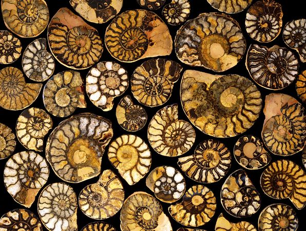
The Permian extinction killed off some 90 percent of species, including these goniatite mollusks. Photograph by Vaughan Fleming, Photo Researchers
Extinctions during the early Triassic period left Earth a virtual wasteland, largely because life literally couldn't take the heat, a new study suggests.
Between 247 to 252 million years ago, Earth was reeling from a mass extinction called the end-Permian event. The die-off had wiped out most life on Earth, including most land plants. The planet was baking, and life at the Equator struggled to survive.
Plants gobble up carbon dioxide, which warms the planet. So without them, Earth became "like a runaway greenhouse—it [started] to get out of control," said study co-author Paul Wignall, a paleontologist at England's Leeds University.
The few life-forms that had survived the Permian extinction—such as hardier snails and clams—died in the deadly heat, leaving Earth a virtual "dead zone" for five million years, said Wignall.
Stagnant-Earth Puzzle Solved
For the study, Wignall and colleagues studied tiny fossils taken from shallow seas in southern China, which at the time was at the Equator.
By studying oxygen isotopes in the fossils that serve as "reliable" proxies for seawater temperatures, the researchers found that these particular post-Permian seas reached 104 degrees Fahrenheit (40 degrees Celsius) at the surface—levels the study authors call lethally hot. The modern average for the same area is between 77 and 86 degrees Fahrenheit (25 and 30 degrees Celsius).
Those high temps may help solve a longstanding scientific head-scratcher: Why did Earth take five million years to recover from the Permian extinction, versus a few hundred thousand after other mass extinctions? Apparently, it was just too darned hot.
The World at Its Worst
Could it happen again? "In theory it could," Wignall said.
Earth's average global temperature has increased by about 1.4 degrees Fahrenheit (0.8 degree Celsius) since 1880, according to NASA's Goddard Institute for Space Studies. Two-thirds of that warming has happened since 1975.
But even with current warming trends, "we're a long, long way to getting to this severe."
For one thing, most of Earth's plant life would have to be wiped out first—an unlikely scenario under current models, Wignall said.
But at geologic time scales, he added, "We're showing just how bad the world could get."
news.nationalgeographic.com


