
Latest Post
Showing posts with label earth. Show all posts
Showing posts with label earth. Show all posts
Sea Level Rise Accelerating For US East Coast
Written By Unknown on Monday, November 19, 2012 | 5:06 PM

A striking image of Verrazano Bridge in Brooklyn as Hurricane Sandy approaches on Oct. 29, 2012.
CREDIT: Carlos Ayala
CHARLOTTE, N.C. — This summer the North Carolina Senate passed a bill banning researchers from reporting predicted increases in the rate of sea level rise. But the ocean, unbound by legislation, is rising anyway — and in North Carolina this rise is accelerating, researchers reported here yesterday (Nov. 6) at the annual meeting of the Geological Society of America.
On the coast of North Carolina and at other so-called "hotspots" along the U.S. East Coast, sea levels are rising about three times more quickly on average than they are globally, researchers reported during a session devoted to sea level rise.
That's the fastest rise in the world.
"What we're seeing here is unique," said Asbury Sallenger, an oceanographer at the U.S. Geological Survey in St. Petersburg, Fla.
The accelerating rise
And this rise is accelerating, said Tal Ezer, a researcher at Old Dominion University in Norfolk, Va.
His colleague, Larry Atkinson, said computer models suggest that if this acceleration continues at the same pace, the rise along the East Coast — from North Carolina to Massachusetts — could be 5.3 feet (1.6 meters) by 2100.
Sea levels on this stretch of land have climbed as much as 1.5 inches (3.7 centimeters) per decade since 1980, while globally they've risen up to 0.4 inches (1.0 cm) per decade, according to a study by Sallenger published in June.
Why is the rise accelerating? Researchers said it's due in part to the sinking of land in the mid-Atlantic, a process called subsidence. Also, warming oceans have decreased the flow rate of the Gulf Stream, a current that ferries warm water from the Caribbean and Gulf of Mexico northeast across the Atlantic. With a less intense Gulf Stream, water is backed up toward the shore, causing sea level rise. Differences in coastal geography, temperature and salinity (salt content) cause different rates of rise along the East Coast, Atkinson said.
Sea levels worldwide are rising due to melting of glaciers in the Arctic and Antarctic, as well as expansion of water caused by heating, researchers said. [8 Ways Global Warming Is Already Changing the World]
All too vulnerable
Although the original bill by the North Carolina Senate was rejected by the state House of Representatives in June following international outcry, a compromise was reached that bans state agencies from making plans or laws based on exponential extrapolations of sea level rise for the next three to four years, according to local news reports.
North Carolina lawmakers were the butt of jokes at this session on sea level rise, but underlying the humor was a sense of anxiety, even desperation.
One session titled "Does acceleration matter?" concluded that yes, of course it does, but current efforts to deal with the problem are completely insufficient.
Robert Young, a scientist at Western Carolina University, said that by developing low-lying coastal areas, we are all too vulnerable to storms at current sea levels, as was made clear last week in the New York area by the devastation wrought by Hurricane Sandy.
"We cannot expect as a society to respond to accelerating sea level rise if we can't even respond to linear sea level rise and storms," he said. "Every single storm is an opportunity to take a step back from the coast. Instead, coastal development continues."
Young cited the example of Dauphin Island, Ala., which has been inundated by storms eight times in 26 years. Each time, he said, the federal government has stepped in and paid to rebuild the island's infrastructure. "That's crazy," Young said.
Some uncertainty
There is some uncertainty and disagreement between scientists about the particulars of the accelerating sea level rise. One of the biggest questions is how long this acceleration might last. Sallenger's calculations suggest it could continue for about a century, while others are less certain.
But there is no question that sea levels are rising and that this rise has significant impacts. An internal study by the Hunting Ingalls shipyard in Newport News, Va., the sole builder of nuclear-powered aircraft carriers, found that squalls capable of bringing threatening storm surges near its facility have become more common. These storms once occurred every 80 years; now they are likely to happen every two years, Atkinson said.
Sea levels are measured by tidal gauges are various points along the East Coast. One gauge at Sandy Hook, N.J., was reporting a 0.15 inch (3.9 mm) rise per year, according to the National Oceanographic and Atmospheric Administration.
But it won't be collecting any more data, said John Boon, a researcher at the Virginia Institute of Marine Science. It was destroyed by Hurricane Sandy.
Douglas M. Main, OurAmazingPlanet Staff Writer
http://www.livescience.com/
Viet Nam: Serious Land subsidence in Lam Dong
Viet Nam: Serious Land subsidence in Lam Dong province- Length; 656ft, Width; 66ft, Depth; 23~33ft


Nov 15, 2012
Lam Dong province examined the phenomenon of subsidence occurred from 3-10 in irrigation reservoir Dak Long Thuong (Loc Ngai, Bao Lam district).
Subsidence location identified in the coffee garden of 1.5 hectares of family Ms. Nguyen Thi potential, cardiac irrigation dam about 250m northwest.
Area subsided lost about 5.000m ², the average width of 20 m, the arc length of about 200 m, a depth of 7-10m. Locations around many local rift subsidence 10-50cm wide.
poleshift.ning.com


Nov 15, 2012
Lam Dong province examined the phenomenon of subsidence occurred from 3-10 in irrigation reservoir Dak Long Thuong (Loc Ngai, Bao Lam district).
Subsidence location identified in the coffee garden of 1.5 hectares of family Ms. Nguyen Thi potential, cardiac irrigation dam about 250m northwest.
Area subsided lost about 5.000m ², the average width of 20 m, the arc length of about 200 m, a depth of 7-10m. Locations around many local rift subsidence 10-50cm wide.
poleshift.ning.com
Warming Temperatures Will Change Greenland's Face, Experts Predict
Written By Unknown on Sunday, November 18, 2012 | 8:16 PM

Professor Marco Tedesco balances at the edge of a supraglacial lake. (Credit: Copyright M. Tedesco/WWF)
Global climate models abound. What is harder to pin down, however, is how a warmer global temperature might affect any specific region on Earth.
Dr. Marco Tedesco, associate professor of earth and atmospheric sciences at The City College of New York, and a colleague have made the global local. Using a regional climate model and the output of three global climate models, they can predict how different greenhouse gas scenarios would change the face of Greenland over the next century and how this would impact sea level rise.
The resulting fine-scale model gives a high-resolution picture of the island's future. "We put Greenland under a microscope to see what accounts for melting and for ice mass changes in different regions," said Professor Tedesco.
He and his colleague, Xavier Fettweis of the University of Liege, Belgium, reported their results online November 8 in Environmental Research Letters.
They compared two possible future CO2 scenarios: a concentration of carbon dioxide in the atmosphere projected for the end of the century of 850 parts per million (ppm) versus a more aggressive projection of 1370 ppm. The first approximates the current rate of increase.
The Greenland ice sheet would lose more ice and snow to melting than it would accumulate in both scenarios. Basins on the southwest and north coasts would suffer the greatest losses. Temperatures would only have to increase by 0.6 to 2.16 degrees Celsius (1.8-3.9 ° F) to tip the balance into more loss than gain.
The new model shows how a melting would alter the topography of "one of the world's refrigerators," potentially affecting adjacent ocean circulation and salinity, and speeding further melting.
Though dramatic, Professor Tedesco said the predictions he reported might be too conservative. "They don't take into account progressive effects of the changing elevations and topography and the acceleration of ice sheet movement." These results, however, represent a step forward toward understanding the potential repercussions of warming temperatures; an improvement on models that give a much coarser view into the future, he added.
"Some areas will be 400 meters below the current elevation just because of melting. This might very well impact the speed and amount of ice that is flowing to the ocean. It would increase the rate of melting, because conditions get warmer at lower elevations" he noted. "Imagine an ice cream that is melting much faster in one area. This will change the shape of the ice mass over Greenland."
This work was supported by the National Science Foundation.
www.sciencedaily.com
Guatemala earthquake: Dozens killed, says Perez Molina
Written By Unknown on Wednesday, November 7, 2012 | 4:02 PM
Thirty-nine people have been killed and many more are missing after a 7.4-magnitude quake hit off the Guatemala's Pacific coast, the president has said.

Firefighters were searching the rubble for survivors in San Marcos region
Otto Perez Molina declared a national alert and advised people to evacuate tall buildings as a precaution.
Officials said landslides had buried roads and it would take 24 hours to restore links to the quake-hit area.
Frightened people fled from offices and homes around the region, as buildings shook from Mexico City to San Salvador.
Quake officials said the tremor hit at about 10:35 local time (1635 GMT) about 23km (15 miles) from the Guatemalan town of Champerico.

Mr Perez Molina has given several news conferences, each time raising the number of casualties.
He was touring the affected area and said 39 deaths had now been confirmed in what he called a tragedy.
He had earlier said 15 people were believed to be trapped under ground and about 100 people were missing.
The national voluntary fire service gave details on its twitter feed of the damage across the San Marcos region, describing how firefighters had pulled five bodies from the rubble including that of an 11-year-old boy.
The service said 14 houses had been destroyed in Quetzaltenango, a city that houses dozens of language schools popular with tourists.
Firefighters earlier said a school had collapsed in San Pedro Sacatepequez, also in the San Marcos area.
The US Pacific Tsunami Warning Center said in a statement there was no threat of a destructive widespread tsunami.
But it added: "Earthquakes of this size sometimes generate local tsunamis that can be destructive along coasts located within a hundred kilometres of the earthquake epicentre."
The region is often hit by quakes, which have periodically caused huge damage and many deaths.
Are you in the region? Have you been affected by the earthquake? You can contact the BBC using the form below.
Send your pictures and videos to yourpics@bbc.co.uk or text them to 61124 (UK) or +44 7624 800 100 (International).
www.bbc.co.uk
Land subsidence – flooding is the “global warming”
Land subsidence – flooding is the “global warming“.

The story of climate change is no less interesting. Because now it has turned more and more to talk about this enough. Become subject to it. With the change of climate variability and change things around. Affect many. The story will be told today, there is another interesting story about land subsidence – caused flooding and many are caught off guard by it.
The “global warming” and its impact on the broader story is spread around. I had a talk entitled “The impact of global warming. That affect coastal Thailand “, there is another interesting story. The current growth of the industry. The amount of gas in the 21st century, it is expected that high temperature of 6 degrees Celsius, leading to the occurrence of hurricanes and natural disturbances that occur with. Polar ice is completely melted. Impact on the high seas rise with it. Will result in the production of natural food. Water in the summer is out there. Mosquitoes can be a severe disease with increased earthquake faults will be affected more and more by the earthquake, tsunami. Volcano to blow it up. There are also mega tsunami itself. Consequences to the Internet. There is more rain in flood bar high. This is an interesting story. Should be aware that we do more with it.
Although global warming may not affect us directly to Thailand at this time that But the effect is stronger the wind, waves, coastal erosion, 2815 km long, covering 23 provinces in the Gulf of Thailand have discovered that there is a crisis that has eroded the average over 5 meters / year that it is. areas with erosion rates of 1-5 m / year in 14 provinces.
The Andaman is a crisis that has eroded areas average more than 5 m / year in 5 provinces in areas with erosion rates of 1-5 m / year in the province was 90.5 km from exploiting it. appropriate Sediment accumulation less. The development of the information system based on land use change processes natural high enough.
This is a fascinating story that we come together today itself.
Thanks great article from writer.dek-d.com.
www.naomitosy.com
Asteroid 'Nibiru' On Collision Course With Earth, According To NASA Whistleblowers

According to leaks by unnamed NASA employees and scientists, an asteroid dubbed 'Nibiru' is heading in a direct path towards earth, with up to 30% chance of collision. Understandably NASA is keeping quiet for the moment as to not incite panic, and to get all the facts before making an official press release.
Though some unconfirmed rumours include the asteroid being the size of texas, and the estimated date of collision being some time during November-December 2012. NASA has neither confirmed or denied any of these claims.
http://ireport.cnn.com/docs/DOC-872812
Heavy rain and floods in Slovenia
Written By Unknown on Tuesday, November 6, 2012 | 12:37 PM
Heavy rain in Slovenia has caused several regional roads, mostly in western Slovenia, to be closed due to flooding rivers, minor landslides and a number of fallen trees.


www.demotix.com

Floods in Slovenia caused a lot of trouble and fear among the population. Water has flooded many buildings and roads and triggered a series of landslides. It is closed several roads and rail links. Red alarm for large parts of the country. Centenary water: Severe clock on the Drava river, sirens and record levels of river flow. Dravograd suffered great disaster, black cut off from the world.Traffic information center for the State Highway on its website indicates that almost half of the roads in our country crippled by flood.
www.siol.net, poleshift.ning.com


www.demotix.com

Floods in Slovenia caused a lot of trouble and fear among the population. Water has flooded many buildings and roads and triggered a series of landslides. It is closed several roads and rail links. Red alarm for large parts of the country. Centenary water: Severe clock on the Drava river, sirens and record levels of river flow. Dravograd suffered great disaster, black cut off from the world.Traffic information center for the State Highway on its website indicates that almost half of the roads in our country crippled by flood.
www.siol.net, poleshift.ning.com
Ancient Supervolcano Affected the Ends of the Earth
About 74,000 years ago, the Toba volcano on the Indonesian island of Sumatra erupted with catastrophic force. Estimated to be 5,000 times larger than the 1980 eruption of Mount St. Helens, it is believed to be the largest volcanic event on Earth in the last 2 million years.

Sumatra, Earth's sixth-largest island, spied from space. CREDIT: NASA.
Toba spewed enough lava to build two Mount Everests, it produced huge clouds of ash that blocked sunlight for years, and it the left behind a crater 31 miles (50 kilometers) across. The volcano even sent enough sulphuric acid into the atmosphere to create acid rain downpours in the Earth's polar regions, which researchers have found evidence of in deep ice cores.
"We have now traced this acid rain in the ice caps on Greenland and Antarctica," glaciologist Anders Svensson, of the Niels Bohr Institute at the University of Copenhagen, said in a statement.
"We have long had an idea of at what depth the Toba eruption could be found in the Greenland ice cap, but we found no ash, so we could not be sure," Svensson added. "But now we have found the same series of acid layers from Toba in the Greenland ice sheet and in the ice cap in Antarctica. We have counted the annual layers between acid peaks in ice cores from the two ice caps and it fits together."
The ice cores could offer more evidence about how the changed Earth's climate was drastically changed in the years after the colossal eruption. Researchers had previously estimated that such an event would have prompted a cooling of up to 10 degrees C (18 degrees F) in the global temperature for decades, but the ice cores show the cooling was probably short and not consistent across the globe.
"In the temperature curves from the ice cores we can see that there is no general global cooling as a result of the eruption," Svensson said. "There is certainly a cooling and large fluctuations in temperature in the Northern Hemisphere, but it becomes warmer in the Southern Hemisphere, so the global cooling has been short."
The new evidence also promises to settle some archaeological debates. The Toba eruption occurred at a critical point in early human history when Homo sapiens were first venturing out of Africa into Asia. However, there is wide disagreement about how early human were affected and whether large parts of the population were wiped out by the blast.
Layers of ash from the Toba eruption have been found in Asia and serve as a very important reference horizon for ancient archaeological clues from this period that are too old to be carbon dated. The ice cores now provide another backdrop against which to place ancient finds.
"The new precise location of the Toba eruption in the ice cores will place the archaeological finds in a climatic context, which will help to shed light on this critical period of human history," Svensson said.
The study is detailed in the journal Climate of the Past.
by LiveScience Staff, www.livescience.com
Greenland May Soon Disappear
Written By Unknown on Monday, November 5, 2012 | 7:20 PM

A panel of scientists told Congress the entire ice mass of Greenland will disappear from the world map if temperatures rise by as little as 2C --3.6 degrees Fahrenheit, with severe consequences for the rest of the world.The fall-out would be felt thousands of miles away from the Arctic, unleashing a global sea level rise of 23 feet. Low-lying cities such as New Orleans would vanish.
Rapid changes in the Earth's core: The magnetic field and gravity from a satellte perspective

Annual to decadal changes in the earth’s magnetic field in a region that stretches from the Atlantic to the Indian Ocean have a close relationship with variations of gravity in this area. From this it can be concluded that outer core processes are reflected in gravity data. This is the result presented by a German-French group of geophysicists in the latest issue of PNAS (Proceedings of the National Academy of Sciences of the United States).
The main field of the Earth’s magnetic field is generated by flows of liquid iron in the outer core. The Earth’s magnetic field protects us from cosmic radiation particles. Therefore, understanding the processes in the outer core is important to understand the terrestrial shield. Key to this are measurements of the geomagnetic field itself. A second, independent access could be represented by the measurement of minute changes in gravity caused by the fact that the flow in the liquid Earth’s core is associated with mass displacements. The research group has now succeeded to provide the first evidence of such a connection of fluctuations in the Earth’s gravity and magnetic field.
They used magnetic field measurements of the GFZ-satellite CHAMP and extremely accurate measurements of the Earth’s gravity field derived from the GRACE mission, which is also under the auspices of the GFZ. “The main problem was the separation of the individual components of the gravity data from the total signal,” explains Vincent Lesur from the GFZ German Research Centre for Geosciences, who is involved in the study. A satellite only measures the total gravity, which consists of the mass fractions of Earth’s body, water and ice on the ground and in the air. To determine the mass redistribution by flows in the outer core, the thus attained share of the total gravity needs to be filtered out. “Similarly, in order to capture the smaller changes in the outer core, the proportion of the magnetic crust and the proportion of the ionosphere and magnetosphere need to be filtered out from the total magnetic field signal measured by the satellite,” Vincent Lesur explains. The data records of the GFZ-satellite missions CHAMP and GRACE enabled this for the first time.
During the investigation, the team focused on an area between the Atlantic and the Indian Ocean, as the determined currents flows were the highest here. Extremely fast changes (so-called magnetic jerks) were observed in the year 2007 at the Earth’s surface. These are an indication for sudden changes of liquid flows in the upper outer core and are important for understanding the magneto-hydrodynamics in the Earth’s core. Using the satellite data, a clear signal of gravity data from the Earth’s core could be received for the first time.
This results in consequences for the existing conceptual models. Until now, for example, it was assumed that the differences in the density of the molten iron in the earth’s core are not large enough to generate a measurable signal in the earth’s gravitational field. The newly determined mass flows in the upper outer core allow a new approach to Earth’s core hydrodynamics.
scienceblog.com
Found: The Climate Change Trigger For Earth's Last Big Freeze
Did the flood waters from melting of the Laurentide Ice Sheet in the last major cold episode on Earth about 12,900 years ago flow northwest into the Arctic firs, or east via the Gulf of St. Lawrence to weaken ocean thermohaline circulation and have a frigid effect on global climate?
It's a debate that has gone on for decades but new, high-resolution global ocean circulation models claim to have an answer/ The researchers report that the flood must have flowed north into the Arctic first down the Mackenzie River valley. They also say that if it had flowed east into the St. Lawrence River valley, Earth's climate would have remained relatively unchanged.
Events leading up to the sharp climate-cooling period known as the Younger Dryas, colloquially known as the "Big Freeze," unfolded after glacial Lake Agassiz, at the southern edge of the Laurentide ice sheet covering Hudson Bay and much of the Canadian Arctic, catastrophically broke through an ice dam and dumped thousands of cubic kilometers of fresh water into the ocean in a short time.
This massive influx of frigid fresh water injected over the surface of the ocean is assumed to have halted the sinking of very dense, saltier, colder water in the North Atlantic that drives the large-scale ocean circulation, the thermohaline circulation, that transports heat to Europe and North America. The weakening of this circulation caused by the flood resulted in the dramatic cooling of North America and Europe.

A new model of flood waters from melting of the Laurentide Ice Sheet and large glacial lakes along its edge that covered much of North America from the Arctic south to New England over 13,000 years ago, shows the meltwater flowed northwest into the Arctic first. This weakened deep ocean circulation and led to Earth’s last major cold period. A new model of flood waters from melting of the Laurentide Ice Sheet and large glacial lakes along its edge that covered much of North America from the Arctic south to New England over 13,000 years ago, shows the meltwater flowed northwest into the Arctic first. This weakened deep ocean circulation and led to Earth’s last major cold period. Credit: Alan Condron, UMass Amherst
"This episode was the last time the Earth underwent a major cooling, so understanding exactly what caused it is very important for understanding how our modern-day climate might change in the future," University of Massachusetts Amherst geoscientist Alan Condron said in their statement.
They say their global, ocean-ice circulation model is 10 to 20 times more powerful than previously attainable, and it allowed them to compare how meltwater from the two different drainage outlets was delivered to the sinking regions in the North Atlantic. They found the original hypothesis proposed in 1989 by Wally Broecker of Columbia University suggesting that Lake Aggasiz drained into the North Atlantic down the St. Lawrence River would have weakened the thermohaline circulation by less than 15 percent.
Condron and Winsor say this level of weakening is unlikely to have accounted for the 1,000-year cold climate event that followed the meltwater flood. Meltwater from the St. Lawrence River actually ends up almost 1,900 miles (3,000 km) south of the deep water formation regions, too far south to have any significant impact on the sinking of surface waters, which explains why the impact on the thermohaline circulation is so minor.
By contrast, their model says that when the meltwater first drains into the Arctic Ocean, narrow coastal boundary currents can efficiently deliver it to the deep water formation regions of the sub-polar north Atlantic, weakening the thermohaline circulation by more than 30 percent. They conclude that this scenario, showing meltwater discharged first into the Arctic rather than down the St. Lawrence valley, is "more likely to have triggered the Younger Dryas cooling."
Condron adds, "Our results are particularly relevant for how we model the melting of the Greenland and Antarctic Ice sheets now and in the future. It is apparent from our results that climate scientists are artificially introducing fresh water into their models over large parts of the ocean that freshwater would never have reached. In addition, our work points to the Arctic as a primary trigger for climate change. This is especially relevant considering the rapid changes that have been occurring in this region in the last 10 years."
Published in Proceedings of the National Academy of Sciences.
www.science20.com
Whales stranded near King Island, north-west Tasmania

Whale stranding on New Year island, off coast of King Island, off north-west Tasmania coast, on November 3, 2012.

Deceased dolphins after stranding at King Island, Tasmania, November 4, 2012. About 100 whales and dolphins lay beached for up to two nights in one of Tasmania's largest strandings since 2009.
www.abc.net.au
40 whales die in mass stranding on Indian island

In this handout photograph released by the Andaman and Nicobar Islands Department of Environment and Forestry on October 25, 2012, over 40 short-finned pilot whales lie on the beach in a mass stranding on the west coast of the remote Indian Andaman islands in the Bay of Bengal on October 25, 2012. PHOTO: AFP
NEW DELHI: About 40 whales died in a mass stranding on the west coast of India’s remote North Andaman island in the Bay of Bengal, wildlife officials said on Thursday.
“The short-finned pilot whales were found by fishermen who alerted us and investigations show it was a case of mass stranding,” said Ajai Saxena, a wildlife official in Port Blair, capital of the islands.
Saxena said no previous mass stranding had been reported in the Andamans, but that it was a natural phenomenon that occurs when whales get disoriented and are unable to swim back into deep water.
Stranding is also thought to occur when a pod follows a sick or an injured whale into the shallows, experts say.
Emergency teams and local volunteers headed to the beach near Elizabeth Bay on the North Andaman island where the whales were stranded, but they were unable to help.
“The mammals are so heavy, it is impossible to move them back to the waters,” Saxena told AFP.
A post-mortem has been conducted on one of adults, which weighed two tonnes.
The Andaman and Nicobar islands are Indian territory, though they are at least 600 miles (1,000 kilometres) from the mainland and are closer to the coast of Myanmar.
tribune.com.pk
Raw: Salmon Swimming Upstream on Road
Written By Unknown on Thursday, November 1, 2012 | 3:55 PM

www.youtube.com, AssociatedPress: Salmon are seen swimming upstream on a road near Seattle, Washington. A dog walking along catches one of the fish in its mouth, then moseys along the watery road. (Nov. 1)
Dawn to Dusk: Hurricane Sandy, October 29, 2012, Super Rapid Scan
This time-lapse video shows the evolution of Hurricane Sandy from dawn to dusk on October 29, 2012. The video was compiled from satellite images taken every minute from 6:00 a.m. to 6:30 p.m. EDT.

The images were collected in "super rapid scan" mode by the GOES-14 satellite, which observes Earth from geostationary orbit (35,800 km or 22,300 miles) over the Western Hemisphere. The changing angles of sunlight highlight the motions and different structures in the clouds. GOES satellites are built by NASA and operated by the National Oceanic and Atmospheric Administration.
NASA animation by Kevin Ward, using images from NOAA and the University of Wisconsin-Madison Cooperative Institute for Meteorological Satellite Studies.

The images were collected in "super rapid scan" mode by the GOES-14 satellite, which observes Earth from geostationary orbit (35,800 km or 22,300 miles) over the Western Hemisphere. The changing angles of sunlight highlight the motions and different structures in the clouds. GOES satellites are built by NASA and operated by the National Oceanic and Atmospheric Administration.
NASA animation by Kevin Ward, using images from NOAA and the University of Wisconsin-Madison Cooperative Institute for Meteorological Satellite Studies.
http://earthobservatory.nasa.gov
NASAEarthObservatory - www.youtube.com
Video of extreme global weather events and other weird phenomena in October 2012

Snow in Springtime in Australia; deluge in the UK, Nigeria, southern Spain and the US; fireballs seen everywhere; tornadoes and strong winds in southern France; another zombie cannibal attack, this time in China; a hurricane in northeastern US; UFOs diving into volcanoes; large earthquakes; sudden sinkholes swallowing and killing people in China ...it's been another bizarre month here on the Big Blue Marble.
fidockave213
YouTube
Tens of thousands flee homes as cyclone Nilam hits India

INDIA, CHENNAI : Onlookers gather on the beach after the oil tanker ship Pratibha Cauvery ran aground off the coast in Chennai on October 31, 2012. The tanker ran aground off the city coast due to high winds before the landfall of Cyclone Nilam, a report said. AFP PHOTO/SESHADRI SUKUMAR
Tens of thousands of people have been evacuated from their homes in southeast India as a cyclone hit coastal areas, with officials warning of possible flooding and damage to houses.
Cyclone Nilam struck the historic port of Mahabalipuram, 50 kilometres south of state capital Chennai and is forecast to cross the states of Tamil Nadu and Andhra Pradesh overnight.
“We have evacuated thousands of people from Mahabalipuram and nearby coastal districts. We are monitoring the situation in Chennai but have not ordered any evacuations there,” said a local disaster management official.
Chennai’s port has been closed, as well as nearly 300 schools in the city. Both government and private offices closed early to allow people to reach their homes or nearby shelters.
The latest update from the Indian Meteorological Department says that winds gusting up to 100 kilometers an hour would trigger flooding of low-lying areas due to a sea surge and heavy rain. It also warned the cyclone would likely cause extensive damage to houses and uproot large trees, leading to power blackouts and communication problems.
Local authorities said they were preparing helicopters and boats in case of an emergency. Cyclone shelters, schools and community halls have also been opened to serve as potential relief camps.
Earlier, the cyclone hit Sri Lanka, where thousands had to evacuate their homes.
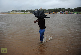
An Indian man wades through a flooded area in Chennai on October 31, 2012. (AFP Photo)

An Indian man wades through a flooded street in Chennai on October 31, 2012. (AFP Photo)

Onlookers gather on the beach after the oil tanker ship Pratibha Cauvery ran aground off the coast in Chennai on October 31, 2012. (AFP Photo/Seshadri Sukumar)

Photographed through the window of an ambulance, a crewmember of the oil tanker ship Pratibha Cauvery which ran aground receives treatment following his rescue off the beach in Chennai on October 31, 2012. (AFP Photo/Seshadri Sukumar)

A tree rests on top of a motor car following heavy winds in the run up to Cyclone Nilam in Chennai on October 31, 2012. (AFP Photo/Str)

Ambulances and police vehicles are seen on the beachfront after the oil tanker ship Pratibha Cauvery ran aground off the coast in Chennai on October 31, 2012. (AFP Photo/Seshadri Sukumar)

Women shield their faces during strong winds at Marina beach in the southern Indian city of Chennai October 31, 2012. (Reuters/Stringer India)
http://rt.com
Scientist predict sea level rise from burning of all Earth's fossil fuels
Written By Unknown on Wednesday, October 31, 2012 | 8:39 PM

Study by scientists has found that burning all the Earth’s reserves of fossil fuels could cause sea levels to rise by as much as five metres.
A study by University of Liverpool scientists has found that burning all the Earth's reserves of fossil fuels could cause sea levels to rise by as much as five metres – with levels continuing to rise for typically 500 years after carbon dioxide emissions ceased. Climate change, including sea level rise, is usually discussed in terms of the next 100 years and this is demonstrated by the various research assessments used by the Intergovernmental Panel on Climate Change (IPCC).
A paper published in Geophysical Research Letters found climate change has much longer-term implications for our planet. The paper, How warming and steric sea level rise relate to cumulative carbon emissions, considers how sea level may change over much longer timescales due to ocean warming.
Dr Ric Williams from the School of Environmental Sciences, in collaboration with scientists at the University of Cambridge, the University of Bristol and the National Oceanographic Centre, found that surface warming, and sea level rise connected to density changes in the ocean (called steric changes), increase nearly linearly with increased carbon emissions, when viewed in the future many centuries after emissions cease.
The analysis studied particular issues involving the various feedbacks in the climate system including those from ocean acidity and solubility changes in the ocean. The implied steric sea level rise ranged from 0.7 metres to 5 metres if all the planet's conventional fossil fuel reserves were burned – representing a cumulative emission of about five trillion tonnes of carbon – which could happen 500 years or more after emissions cease. The study only predicted sea level rise from the warming of the oceans and did not include the additional contribution from the melting of the great ice sheets.
Journal reference: Geophysical Researc
Provided by University of Liverpool
phys.org
Bolivian farmers urge rethink on Mother Earth law

The Andean nation is a small producer of soybeans compared with its giant agricultural neighbors, Brazil and Argentina, but output and exports of the oilseed have jumped in recent years due to improved crop yields and bigger plantings.
Production should reach 2.4 million metric tons (2.6 million tons) this year, of which about 80 percent would be exported, industry groups say.
Virtually all Bolivian soy uses GM seeds and the law signed by Morales earlier this month has rattled growers in the lowland east, historically a bastion of opposition to the Aymara Indian president -- a vocal advocate of organic farming methods and Pachamama, which means Mother Earth in the Andes.
The legislation, which former coca farmer Morales has called a means "to live in equilibrium and harmony with Mother Earth," also calls for limits on the expansion of farming into new areas and assigns a spiritual value to land beyond its social and economic function.
Soy plantings are due to start in earnest in Bolivia's lush lowland plains in the next few weeks, but some industry figures say uncertainty over the new rules could affect farmers' plans.
"It's possible with this uncertainty that some people will avoid sowing or sow less using any non-GM seeds they can get hold of," said Fernando Asturizaga, an advisor from the Anapo farming association based in the eastern city of Santa Cruz.
Agricultural leaders are holding talks with the government to call for changes to the GM ban and express broader concerns about the legislation. A second meeting between farm groups and officials was due to take place on Wednesday.
"We want them to understand the potential consequences of the measures contained in the Mother Earth legislation and to make changes or clarifications either in the implementation of this law or through a new law," Asturizaga said.
Soy exports brought in about $800 million last year, making the oilseed the country's third-biggest foreign currency earner after minerals and natural gas, according to the Bolivian Foreign Trade Institute (IBCE).
Most of the shipments went to Venezuela and other Andean countries in the form of soyoil and soymeal.
Growers say the new regulations may also threaten the production of other crops such as corn, sugar, rice and sorghum which farmers use in rotation with soybeans. They say that could drive up food costs in South America's poorest country.
The GM ban, which would take effect gradually under the law, could also compound the impact of high transport costs in the landlocked country that make it harder to compete, critics say.
"It's like running the 100-meters but shooting ourselves in the foot first. We're giving our neighbors too many advantages," said Marcelo Traverso, president of the APIA agricultural suppliers' association.
"It's a big step backwards that's going to have serious economic repercussions for the Bolivian farmer."
(Editing by Chizu Nomiyama)
By Helen Popper, www.reuters.com
In Hurricane Sandy's Fury, The Fingerprint Of Climate Change

Residents along the East Coast are bracing for a storm that has prompted evacuations and shut down transit systems, schools and businesses. The map above shows the evolution of Hurricane Sandy's past and predicted path. Click the map for more.
Last month, Mike Tidwell, director of Maryland's Chesapeake Climate Action Network and the author of the 2006 book The Ravaging Tide -- which detailed the expected rise in extreme weather events that will come with global warming -- received a pamphlet in the mail from his insurance company, Travelers. The full-color flier depicted a typical suburban home with a lashing storm looming on the horizon.
Federal disaster declarations are up, the pamphlet declared. Average winter storm losses have doubled since the 1980s. Thunderstorms last year caused over $25 billion in damages, more than double the previous record.
"That flier was astonishing," said Tidwell. "I couldn't remember ever getting anything like that before."
The implication was simple: Given the bounty of scientific and statistical evidence now in hand, insurance companies can't afford to dither over whether climate change is real -- and really, neither can anyone else. Today, another multibillion-dollar weather disaster -- the very sort that scientists have been predicting for years would increase in frequency and intensity as the planet heats up -- is now bearing down on the American East Coast. Roads and subways and homes will flood and lives might well be lost (the death toll in the Caribbean already is as high as 65). Property damages from wind and storm surges could break records. And as many as 10 million people will likely lose power once Hurricane Sandy comes ashore somewhere along the New Jersey coast later tonight.
With one week left before an historic election that, as it happens, has been roundly criticized for its utter lack of high-level discussion of climate change, the smooth functioning of democracy itself might well be undermined by the storm, with the potential for widespread power outages in some areas lasting 10 days or more -- well beyond next Tuesday's scheduled polls.
If ever there was a time for everyone to wake up, Tidwell suggested, it's now.
"The irony is that the two presidential candidates decided not to speak about climate change, and now they are seeing the climate speak to them," said Tidwell. "That's really what's happening here. The climate is now speaking to them -- and to everyone else."
To be sure, a small but shrinking cadre of skeptics still question the basic mechanics of global warming -- including the likelihood that a hotter planet will produce more powerful and deadly storms like Sandy -- but the evidence is, once again, staring the nation in the face.
More than anything else, after all, hurricanes need warm ocean water, usually above 79 degrees Fahrenheit, to thrive. High humidity also adds fuel. Over the last several decades, both ocean temperatures and water vapor have increased in large part due to the burning of fossil fuels, which increases the amount of carbon dioxide and other so-called greenhouse gases in the atmosphere. Such gases act like a blanket around the planet, keeping the sun's heat from bouncing back out into space. That's an important phenomenon for sustaining life, of course, but too much of the blanket effect can make life as we've known it far more difficult.
Many scientists believe the atmospheric concentration of those gases must be kept below 350 parts per million to avoid dramatic and runaway changes in our climate. That benchmark has already been passed.
According to the latest measurements from the National Oceanic and Atmospheric administration, the average global temperature across land and ocean surfaces during September 2012 was 1.21 degrees above the 20th century average. That temperature ties with 2005 as the warmest September in the 133 years that records have been kept.
While scientists admit that unequivocally tying any one particular storm to climate change -- an area of research known as "event attribution science" -- is still very difficult, such hair-splitting is, in practical terms, nearly meaningless.
"We can't blame the existence of a single hurricane on global warming, just like a die weighted to roll sixes can't be blamed for any single roll of a six," said Michael Mann, a physicist and the director of the Earth System Science Center at Pennsylvania State University. Sixes, after all, will sometimes happen anyway, even when the dice aren't loaded, Mann explained.
"But we can see that climate change is playing a role in setting the context for these storms," Mann continued, "in particular the record levels of North Atlantic ocean warmth that is available to feed these storms with energy and moisture."
Kevin Trenberth, head of the Climate Analysis Section at the USA National Center for Atmospheric Research and one of the world's foremost experts on changes to global energy and water cycles, suggested in an email message that Hurricane Sandy represents the "new normal."
"Climate change is changing the weather," Trenberth said. "The past few years have been marked by unusually severe extreme weather characteristic of climate change. The oceans are warmer and the atmosphere above the oceans is warmer and wetter. This new normal changes the environment for all storms and makes them more intense and with much more precipitation."
Rising temperatures are also likely to intensify other storm phenomena. Thunderstorms may become less frequent but more intense, for example. And all that extra moisture also increases the threat of inland flooding, as happened after Hurricane Irene passed over the East Coast last year, contributing to the lion's share of roughly $16 billion in total damages. Add to this that the fact that ocean surges associated with such storms now ride on sea levels that have risen over the last century, and the potential for catastrophic losses is plain.
Which, of course, is why companies like Travelers are reaching out to customers like Tidwell to gently say, 'This stuff is real.' Indeed, the Travelers pamphlet is based on data compiled by the German reinsurance giant Munich Re, one of the largest reinsurance companies in the world. Just last week -- and only days before the first stirrings of Hurricane Sandy were detected in the South Atlantic -- the company produced a nearly 300-page report called "Severe Weather in North America."
According to the report, between 1980 and 2011, the overall losses from weather catastrophes was over $1 trillion in 2011 dollars -- including some $500 billion in insured losses. Hurricane Katrina itself accounted for some $125 billion in losses, according to the Munich Re analysis, and roughly 30,000 people "lost their lives due to weather catastrophes in North America" in the 30 years examined by the report.
"Nowhere in the world is the rising number of natural catastrophes more evident than in North America," the analysis declared. "The study shows a nearly quintupled number of weather-related loss events in North America for the past three decades, compared with an increase factor of 4 in Asia, 2.5 in Africa, 2 in Europe and 1.5 in South America."
In a statement accompanying the report's release, the Head of Munich Re’s Geo Risks Research unit, Peter Höppe, said, "In all likelihood, we have to regard this finding as an initial climate-change footprint in our U.S. loss data from the last four decades. Previously, there had not been such a strong chain of evidence.
"All stakeholders should collaborate and close ranks to support improved adaptation," Höppe added. "In addition, climate change mitigation measures should be supported to limit global warming in the long term to a still manageable level. As North America is particularly exposed to all kinds of weather risks, it especially would benefit from this."
Recent surveys suggest that most Americans now understand the connection between climate change and more severe weather, including a report released just last month by researchers at Yale and George Mason Universities. Among other things, that survey found that 74 percent of Americans agree that "global warming is affecting weather in the United States." That was up 5 points over the last time the question was asked in March.
Whether that popular concern, the risk modeling of insurance giants like Munich Re, or even the ravages of Sandy will nudge frank discussions of climate change to the front and center of the presidential campaign in its waning days, however, is unclear. On Friday, President Obama, in an appearance on the MTV network, fielded a question on the issue from a resident of New Jersey, a state that is staring right down the barrel of Hurricane Sandy.
"We're not moving as fast as we need to," the president said. "And this is an issue that future generations, MTV viewers, are going to have to be dealing with even more than the older generation. So this is a critical issue."
Obama highlighted many of the policies that his administration has pursued over the last four years to begin curbing greenhouse gas emissions, including tough new emissions standards for cars and trucks, and a doubling of wind and solar energy production. But he also said that the problem is compounded by forces beyond the nation's direct control, including increasing emissions in countries like China and India, who "feel that they have to prioritize getting people out of poverty ahead of climate change," the president said.
For his part, Mitt Romney has said little on the topic of global warming, admitting by turns that he believes it is happening but adding that he remains unconvinced about humanity's role in it -- evidenced, perhaps, by his fossil fuel-heavy energy plan for the next four years.
The Romney campaign did not respond to numerous requests for comment on the approach of Sandy and the implications of global warming.
Meanwhile, for Tidwell -- who, when reached by cell phone Monday morning, was busy buying groceries amid the throngs of other Washington, D.C., area residents who were preparing for Sandy -- said continued equivocation on the issue was absurd.
"We've warmed the planet," he said. "Everybody knows we've warmed the planet. So all super-storms are related to climate change now. You can't have a super-storm that's not related to climate change. Does everyone agree that the oceans have warmed? That land temperatures have increased? That there's more moisture in the air?" Tidwell posited. "The answer is yes. So it's impossible to have a super-storm that doesn't have the fingerprint of climate change on it."
www.huffingtonpost.com
Climate Change And Natural Disasters Related, Most Americans Say: Poll
Climate scientists have warned that more frequent hurricanes may be related to climate change, and a new HuffPost/YouGov poll finds that half of Americans think that climate change is indeed related to more frequent and severe natural disasters, although they are more divided on whether Hurricane Sandy specifically was related to global warming. According to the new survey, conducted Oct. 29-30, 51 percent of Americans say climate change is related to more frequent and severe natural disasters, while 23 percent say it is not. Republicans were the only demographic group in the survey in which more respondents said that more frequent and severe disasters were unrelated to climate change (51 percent) than those who said that the disasters were related to climate change (25 percent). Americans ages 65 and over were also somewhat less likely than other groups to say the two phenomena were related -- 40 percent said they were and 37 percent said they were not.


